Xinbuzi geodata
Xinbuzi (Shaanxi) is a seat of a fourth-order administrative division; located in China in Asia/Shanghai (GMT+8) time zone. In our database, there are 1268 cities with bigger population. Compared to other cities in China, 75% of cities are located further ↓South; 80.3% of cities are located further →East and 87.7% of cities have lower elevation than Xinbuzi. Note1


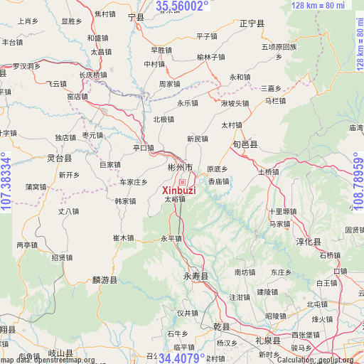
Xinbuzi GPS coordinates[2]
34° 59' 9.564" North, 108° 5' 11.256" East
| Map corner | latitude | longitude |
|---|---|---|
| Upper-left | 35.56002°, | 107.38334° |
| Center: | 34.98599°, | 108.08646° |
| Lower-right: | 34.4079°, | 108.78959° |
| Map W x H: | 128.1×128.1 km | = 79.6×79.6mi |
| max Lat: | 53.31946° ⇑25% North |
| Xinbuzi: | 34.98599° |
| min Lat: | ⇓75% South 18.22056° |
| min Long | Xinbuzi | max Long |
| 75.07348° | 108.08646° | 134.28917° |
| W 19.7%⇐ | ⇒80.3% E |
Elevation
Elevation of Xinbuzi is 1163 m = 3816 ft, and this is 678.2 m = 2225 ft above average elevation for this country.
| Max E: |
5622 m = 18445 ft | 12.3% |
| Xinbuzi | 1163 m 3816 ft | |
| Avg. | 484.8 m = 1591 ft | |
Min E: |
-3 m = -10 ft | 87.7% |
See also: China elevation on elevation.city.
Geographical zone
Xinbuzi is located in North temperate zone (between Tropic of Cancer and the Arctic Circle). Distance of this Northern Tropic circle is 1284.2 km =798 mi to South.| Distance of | km | miles | from Xinbuzi |
|---|---|---|---|
| North Pole | 6117 | 3800.9 | to North |
| Arctic Circle | 3511.1 | 2181.7 | to North |
| Tropic Cancer | 1284.2 | 798 | to South |
| Equator | 3890.1 | 2417.2 | to South |


Nearby cities:
15 places around Xinbuzi: (largest is in red/bold)
• Changning
22.8 km =14.2 mi,  139°
139°
• Chejiazhuang
17 km =10.6 mi,  271°
271°
• Didian
13.8 km =8.6 mi,  241°
241°
• Duma
24.9 km =15.5 mi,  169°
169°
• Hanjia
20.9 km =13 mi,  252°
252°
• Longgao
21.1 km =13.1 mi,  99°
99°
• Mafang
23.3 km =14.5 mi,  162°
162°
• Pingyao
20.3 km =12.6 mi,  210°
210°
• Quzi
16.3 km =10.1 mi,  145°
145°
• Shangyi
23.4 km =14.5 mi, 135°
• Shuikou
8.2 km =5.1 mi,  258°
258°
• Taiyu
6.4 km =4 mi,  202°
202°
• Xiangmiao
12.7 km =7.9 mi,  86°
86°
• Yongping
19.9 km =12.4 mi,  191°
191°
• Yongtai
12.2 km =7.6 mi, 151°
Sources, notices
• [Note1] Compared only with cities in China existing in our database
• [Src1] Map data: © OpenStreetMap contributors (CC-BY-SA)
• [Src2] Other city data from geonames.org with taken over terms of usage.
• [Src3] Geographical zone / Annual Mean Temperature by Robert A. Rohde @ Wikipedia
