Shuizhai geodata
Shuizhai (Henan) is a seat of a fourth-order administrative division; located in China in Asia/Shanghai (GMT+8) time zone. In our database, there are 1268 cities with bigger population. Compared to other cities in China, 68.4% of cities are located further ↓South; 54.1% of cities are located further →East and 63.9% of cities have higher elevation than Shuizhai. Note1


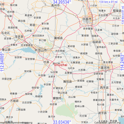
Shuizhai GPS coordinates[2]
33° 37' 18.624" North, 113° 32' 35.412" East
| Map corner | latitude | longitude |
|---|---|---|
| Upper-left | 34.20534°, | 112.84005° |
| Center: | 33.62184°, | 113.54317° |
| Lower-right: | 33.03436°, | 114.2463° |
| Map W x H: | 130.2×130.2 km | = 80.9×80.9mi |
| max Lat: | 53.31946° ⇑31.6% North |
| Shuizhai: | 33.62184° |
| min Lat: | ⇓68.4% South 18.22056° |
| min Long | Shuizhai | max Long |
| 75.07348° | 113.54317° | 134.28917° |
| W 45.9%⇐ | ⇒54.1% E |
Elevation
Elevation of Shuizhai is 78 m = 256 ft, and this is 406.8 m = 1335 ft below average elevation for this country.
| Max E: |
5622 m = 18445 ft | 63.9% |
| Avg. | 484.8 m = 1591 ft | |
| Shuizhai | 78 m = 256 ft | |
Min E: |
-3 m = -10 ft | 36.1% |
See also: China elevation on elevation.city.
Geographical zone
Shuizhai is located in North temperate zone (between Tropic of Cancer and the Arctic Circle). Distance of this Northern Tropic circle is 1132.5 km =703.7 mi to South.| Distance of | km | miles | from Shuizhai |
|---|---|---|---|
| North Pole | 6268.7 | 3895.2 | to North |
| Arctic Circle | 3662.8 | 2276 | to North |
| Tropic Cancer | 1132.5 | 703.7 | to South |
| Equator | 3738.4 | 2322.9 | to South |


Nearby cities:
15 places around Shuizhai: (largest is in red/bold)
• Baohe
18.3 km =11.4 mi,  185°
185°
• Beiwudu
13.8 km =8.6 mi,  90°
90°
• Dengli
6.7 km =4.2 mi,  325°
325°
• Dingying
15.8 km =9.8 mi,  20°
20°
• Gongdian
11 km =6.8 mi,  294°
294°
• Hongzhuangyang
12.3 km =7.6 mi,  348°
348°
• Houji
15.9 km =9.9 mi,  70°
70°
• Jiangdian
15.1 km =9.4 mi,  133°
133°
• Kunyang
18.3 km =11.4 mi,  269°
269°
• Liancun
6.5 km =4 mi,  259°
259°
• Macun
11.3 km =7 mi,  122°
122°
• Mengzhai
10.7 km =6.6 mi,  145°
145°
• Xiantai
13.3 km =8.3 mi,  219°
219°
• Zhanghua
9 km =5.6 mi,  54°
54°
• Zunhuadian
16.2 km =10.1 mi,  305°
305°
Sources, notices
• [Note1] Compared only with cities in China existing in our database
• [Src1] Map data: © OpenStreetMap contributors (CC-BY-SA)
• [Src2] Other city data from geonames.org with taken over terms of usage.
• [Src3] Geographical zone / Annual Mean Temperature by Robert A. Rohde @ Wikipedia
