Guangkuotiandi geodata
Guangkuotiandi (Henan) is a seat of a fourth-order administrative division; located in China in Asia/Shanghai (GMT+8) time zone. In our database, there are 1268 cities with bigger population. Compared to other cities in China, 69.9% of cities are located further ↓South; 56.5% of cities are located further →East and 56.3% of cities have higher elevation than Guangkuotiandi. Note1


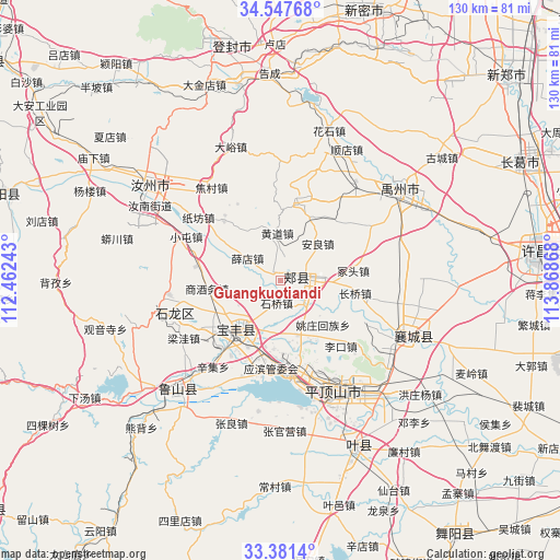
Guangkuotiandi GPS coordinates[2]
33° 57' 59.544" North, 113° 9' 55.98" East
| Map corner | latitude | longitude |
|---|---|---|
| Upper-left | 34.54768°, | 112.46243° |
| Center: | 33.96654°, | 113.16555° |
| Lower-right: | 33.3814°, | 113.86868° |
| Map W x H: | 129.7×129.7 km | = 80.6×80.6mi |
| max Lat: | 53.31946° ⇑30.1% North |
| Guangkuotiandi: | 33.96654° |
| min Lat: | ⇓69.9% South 18.22056° |
| min Long | Guangkuotiandi | max Long |
| 75.07348° | 113.16555° | 134.28917° |
| W 43.5%⇐ | ⇒56.5% E |
Elevation
Elevation of Guangkuotiandi is 122 m = 400 ft, and this is 362.8 m = 1190 ft below average elevation for this country.
| Max E: |
5622 m = 18445 ft | 56.3% |
| Avg. | 484.8 m = 1591 ft | |
| Guangkuotiandi | 122 m = 400 ft | |
Min E: |
-3 m = -10 ft | 43.7% |
See also: China elevation on elevation.city.
Geographical zone
Guangkuotiandi is located in North temperate zone (between Tropic of Cancer and the Arctic Circle). Distance of this Northern Tropic circle is 1170.8 km =727.5 mi to South.| Distance of | km | miles | from Guangkuotiandi |
|---|---|---|---|
| North Pole | 6230.3 | 3871.3 | to North |
| Arctic Circle | 3624.4 | 2252.1 | to North |
| Tropic Cancer | 1170.8 | 727.5 | to South |
| Equator | 3776.7 | 2346.7 | to South |


Nearby cities:
15 places around Guangkuotiandi: (largest is in red/bold)
• Anliang
12.5 km =7.8 mi,  45°
45°
• Baofeng Chengguanzhen
14.1 km =8.8 mi,  220°
220°
• Changqiao
17.2 km =10.7 mi,  101°
101°
• Ciba
16.2 km =10.1 mi,  320°
320°
• Huangdao
11.3 km =7 mi,  356°
356°
• Jiaxian
3.9 km =2.4 mi,  87°
87°
• Lizhuang
16.7 km =10.4 mi,  146°
146°
• Naodian
13.2 km =8.2 mi,  161°
161°
• Shiqiao
5.2 km =3.2 mi,  189°
189°
• Tangjie
15.8 km =9.8 mi,  119°
119°
• Xiaoqi
11.2 km =7 mi,  240°
240°
• Xuedian
8.8 km =5.5 mi,  304°
304°
• Yaozhuang
14 km =8.7 mi,  136°
136°
• Zhongtou
16.2 km =10.1 mi,  81°
81°
• Zhouzhuang
12.6 km =7.8 mi,  201°
201°
Sources, notices
• [Note1] Compared only with cities in China existing in our database
• [Src1] Map data: © OpenStreetMap contributors (CC-BY-SA)
• [Src2] Other city data from geonames.org with taken over terms of usage.
• [Src3] Geographical zone / Annual Mean Temperature by Robert A. Rohde @ Wikipedia
