Maquan geodata
Maquan (Shaanxi) is a seat of a fourth-order administrative division; located in China in Asia/Shanghai (GMT+8) time zone. In our database, there are 1268 cities with bigger population. Compared to other cities in China, 71.6% of cities are located further ↓South; 78.1% of cities are located further →East and 70.6% of cities have lower elevation than Maquan. Note1


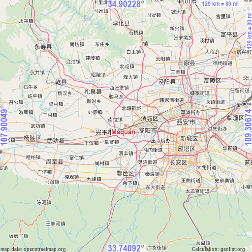
Maquan GPS coordinates[2]
34° 19' 24.996" North, 108° 36' 12.996" East
| Map corner | latitude | longitude |
|---|---|---|
| Upper-left | 34.90228°, | 107.90049° |
| Center: | 34.32361°, | 108.60361° |
| Lower-right: | 33.74092°, | 109.30674° |
| Map W x H: | 129.1×129.1 km | = 80.2×80.2mi |
| max Lat: | 53.31946° ⇑28.4% North |
| Maquan: | 34.32361° |
| min Lat: | ⇓71.6% South 18.22056° |
| min Long | Maquan | max Long |
| 75.07348° | 108.60361° | 134.28917° |
| W 21.9%⇐ | ⇒78.1% E |
Elevation
Elevation of Maquan is 422 m = 1385 ft, and this is 62.8 m = 206 ft below average elevation for this country.
| Max E: |
5622 m = 18445 ft | 29.4% |
| Avg. | 484.8 m = 1591 ft | |
| Maquan | 422 m = 1385 ft | |
Min E: |
-3 m = -10 ft | 70.6% |
See also: China elevation on elevation.city.
Geographical zone
Maquan is located in North temperate zone (between Tropic of Cancer and the Arctic Circle). Distance of this Northern Tropic circle is 1210.5 km =752.2 mi to South.| Distance of | km | miles | from Maquan |
|---|---|---|---|
| North Pole | 6190.6 | 3846.7 | to North |
| Arctic Circle | 3584.7 | 2227.4 | to North |
| Tropic Cancer | 1210.5 | 752.2 | to South |
| Equator | 3816.4 | 2371.4 | to South |


Nearby cities:
15 places around Maquan: (largest is in red/bold)
• Chenyangzhai
9.4 km =5.8 mi,  92°
92°
• Diaotai
8.7 km =5.4 mi,  119°
119°
• Fuzhai
10.8 km =6.7 mi,  223°
223°
• Gaoqiao
12.9 km =8 mi,  133°
133°
• Gudu
8.6 km =5.3 mi,  73°
73°
• Nanwei
6.8 km =4.2 mi,  303°
303°
• Qindu
9.8 km =6.1 mi,  78°
78°
• Shuangzhao
8.8 km =5.5 mi,  8°
8°
• Tianfu
6.6 km =4.1 mi,  187°
187°
• Weibin
4 km =2.5 mi,  102°
102°
• Weicheng
10.4 km =6.5 mi, 85°
• Weiyang
13 km =8.1 mi, 74°
• Wujiabao
9.2 km =5.7 mi, 73°
• Xianyang
9.2 km =5.7 mi, 80°
• Xiwu
4.5 km =2.8 mi,  229°
229°
Sources, notices
• [Note1] Compared only with cities in China existing in our database
• [Src1] Map data: © OpenStreetMap contributors (CC-BY-SA)
• [Src2] Other city data from geonames.org with taken over terms of usage.
• [Src3] Geographical zone / Annual Mean Temperature by Robert A. Rohde @ Wikipedia
