Fuzhai geodata
Fuzhai (Shaanxi) is a seat of a fourth-order administrative division; located in China in Asia/Shanghai (GMT+8) time zone. In our database, there are 1268 cities with bigger population. Compared to other cities in China, 71.3% of cities are located further ↓South; 78.5% of cities are located further →East and 69.8% of cities have lower elevation than Fuzhai. Note1


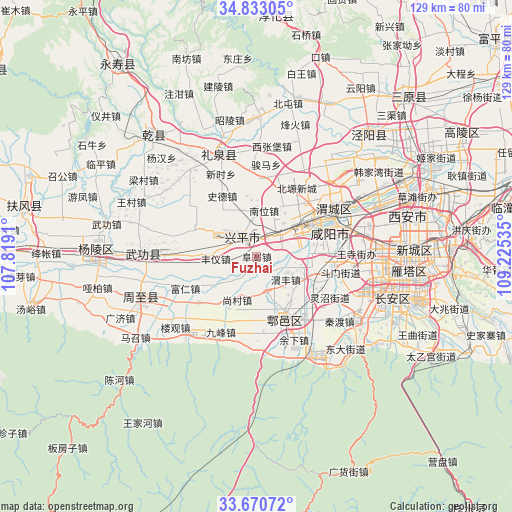
Fuzhai GPS coordinates[2]
34° 15' 14.004" North, 108° 31' 19.992" East
| Map corner | latitude | longitude |
|---|---|---|
| Upper-left | 34.83305°, | 107.8191° |
| Center: | 34.25389°, | 108.52222° |
| Lower-right: | 33.67072°, | 109.22535° |
| Map W x H: | 129.2×129.2 km | = 80.3×80.3mi |
| max Lat: | 53.31946° ⇑28.7% North |
| Fuzhai: | 34.25389° |
| min Lat: | ⇓71.3% South 18.22056° |
| min Long | Fuzhai | max Long |
| 75.07348° | 108.52222° | 134.28917° |
| W 21.5%⇐ | ⇒78.5% E |
Elevation
Elevation of Fuzhai is 408 m = 1339 ft, and this is 76.8 m = 252 ft below average elevation for this country.
| Max E: |
5622 m = 18445 ft | 30.2% |
| Avg. | 484.8 m = 1591 ft | |
| Fuzhai | 408 m = 1339 ft | |
Min E: |
-3 m = -10 ft | 69.8% |
See also: China elevation on elevation.city.
Geographical zone
Fuzhai is located in North temperate zone (between Tropic of Cancer and the Arctic Circle). Distance of this Northern Tropic circle is 1202.8 km =747.4 mi to South.| Distance of | km | miles | from Fuzhai |
|---|---|---|---|
| North Pole | 6198.4 | 3851.5 | to North |
| Arctic Circle | 3592.5 | 2232.3 | to North |
| Tropic Cancer | 1202.8 | 747.4 | to South |
| Equator | 3808.7 | 2366.6 | to South |


Nearby cities:
15 places around Fuzhai: (largest is in red/bold)
• Dawang
13.2 km =8.2 mi,  115°
115°
• Fengyi
10.2 km =6.3 mi,  267°
267°
• Ganhe
10.7 km =6.6 mi,  183°
183°
• Laodian
10 km =6.2 mi,  157°
157°
• Maquan
10.8 km =6.7 mi,  43°
43°
• Nanshi
13.1 km =8.1 mi,  335°
335°
• Nanwei
11.7 km =7.3 mi,  9°
9°
• Shangcun
12 km =7.5 mi,  204°
204°
• Tangfang
14.8 km =9.2 mi,  262°
262°
• Tianfu
6.7 km =4.2 mi,  79°
79°
• Weibin
13.3 km =8.3 mi,  58°
58°
• Weifeng
10.6 km =6.6 mi,  127°
127°
• Xicheng
9.5 km =5.9 mi,  309°
309°
• Xiwu
6.3 km =3.9 mi, 40°
• Zhuangtou
6.5 km =4 mi, 273°
Sources, notices
• [Note1] Compared only with cities in China existing in our database
• [Src1] Map data: © OpenStreetMap contributors (CC-BY-SA)
• [Src2] Other city data from geonames.org with taken over terms of usage.
• [Src3] Geographical zone / Annual Mean Temperature by Robert A. Rohde @ Wikipedia
