Youhuai geodata
Youhuai (Shaanxi) is a seat of a fourth-order administrative division; located in China in Asia/Shanghai (GMT+8) time zone. In our database, there are 1268 cities with bigger population. Compared to other cities in China, 73% of cities are located further ↓South; 74.5% of cities are located further →East and 66.6% of cities have lower elevation than Youhuai. Note1


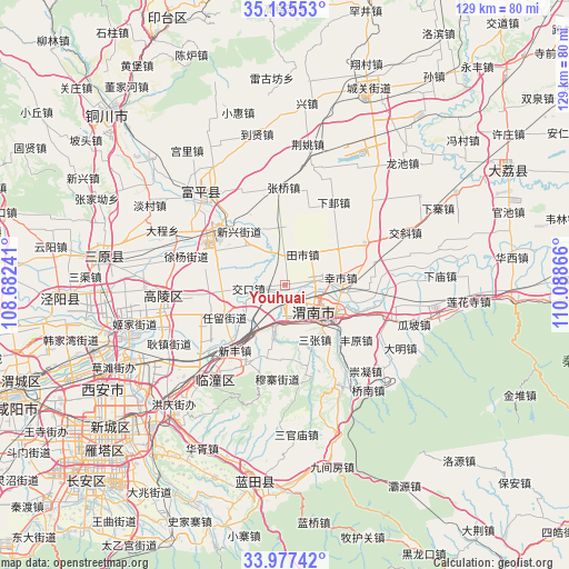
Youhuai GPS coordinates[2]
34° 33' 30.564" North, 109° 23' 7.908" East
| Map corner | latitude | longitude |
|---|---|---|
| Upper-left | 35.13553°, | 108.68241° |
| Center: | 34.55849°, | 109.38553° |
| Lower-right: | 33.97742°, | 110.08866° |
| Map W x H: | 128.8×128.8 km | = 80×80mi |
| max Lat: | 53.31946° ⇑27% North |
| Youhuai: | 34.55849° |
| min Lat: | ⇓73% South 18.22056° |
| min Long | Youhuai | max Long |
| 75.07348° | 109.38553° | 134.28917° |
| W 25.5%⇐ | ⇒74.5% E |
Elevation
Elevation of Youhuai is 354 m = 1161 ft, and this is 130.8 m = 429 ft below average elevation for this country.
| Max E: |
5622 m = 18445 ft | 33.4% |
| Avg. | 484.8 m = 1591 ft | |
| Youhuai | 354 m = 1161 ft | |
Min E: |
-3 m = -10 ft | 66.6% |
See also: China elevation on elevation.city.
Geographical zone
Youhuai is located in North temperate zone (between Tropic of Cancer and the Arctic Circle). Distance of this Northern Tropic circle is 1236.6 km =768.4 mi to South.| Distance of | km | miles | from Youhuai |
|---|---|---|---|
| North Pole | 6164.5 | 3830.4 | to North |
| Arctic Circle | 3558.6 | 2211.2 | to North |
| Tropic Cancer | 1236.6 | 768.4 | to South |
| Equator | 3842.5 | 2387.6 | to South |


Nearby cities:
15 places around Youhuai: (largest is in red/bold)
• Beitun
15.6 km =9.7 mi,  294°
294°
• Guandao
12 km =7.5 mi,  48°
48°
• Guanshan
15 km =9.3 mi,  356°
356°
• Hezhai
7.7 km =4.8 mi,  233°
233°
• Jiaokou
8.2 km =5.1 mi,  263°
263°
• Lingkou
9.3 km =5.8 mi,  194°
194°
• Sanzhang
14.2 km =8.8 mi,  150°
150°
• Shuangwang
10.2 km =6.3 mi,  110°
110°
• Tianshi
8.1 km =5 mi,  28°
28°
• Weinan
12.8 km =8 mi,  118°
118°
• Wutun
12.1 km =7.5 mi,  316°
316°
• Xiangqiao
6.5 km =4 mi,  344°
344°
• Xinshi
12.8 km =8 mi,  82°
82°
• Xinxing
15.8 km =9.8 mi, 319°
• Yujin
13.8 km =8.6 mi,  249°
249°
Sources, notices
• [Note1] Compared only with cities in China existing in our database
• [Src1] Map data: © OpenStreetMap contributors (CC-BY-SA)
• [Src2] Other city data from geonames.org with taken over terms of usage.
• [Src3] Geographical zone / Annual Mean Temperature by Robert A. Rohde @ Wikipedia
