Wutun geodata
Wutun (Shaanxi) is a seat of a fourth-order administrative division; located in China in Asia/Shanghai (GMT+8) time zone. In our database, there are 1268 cities with bigger population. Compared to other cities in China, 73.4% of cities are located further ↓South; 74.9% of cities are located further →East and 67.8% of cities have lower elevation than Wutun. Note1


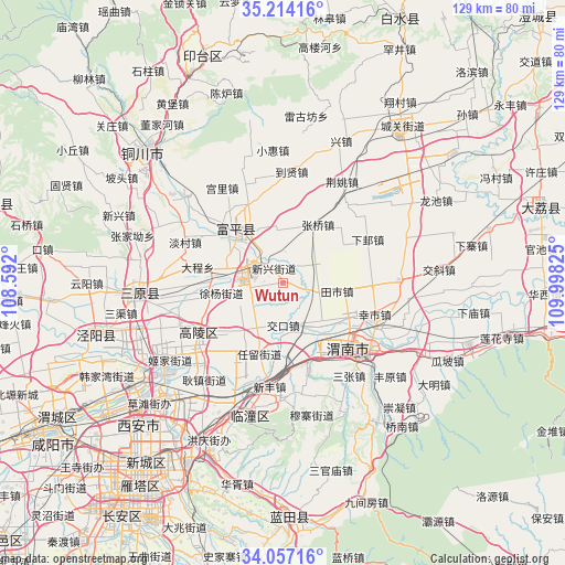
Wutun GPS coordinates[2]
34° 38' 15.648" North, 109° 17' 42.432" East
| Map corner | latitude | longitude |
|---|---|---|
| Upper-left | 35.21416°, | 108.592° |
| Center: | 34.63768°, | 109.29512° |
| Lower-right: | 34.05716°, | 109.99825° |
| Map W x H: | 128.6×128.6 km | = 79.9×79.9mi |
| max Lat: | 53.31946° ⇑26.6% North |
| Wutun: | 34.63768° |
| min Lat: | ⇓73.4% South 18.22056° |
| min Long | Wutun | max Long |
| 75.07348° | 109.29512° | 134.28917° |
| W 25.1%⇐ | ⇒74.9% E |
Elevation
Elevation of Wutun is 373 m = 1224 ft, and this is 111.8 m = 367 ft below average elevation for this country.
| Max E: |
5622 m = 18445 ft | 32.2% |
| Avg. | 484.8 m = 1591 ft | |
| Wutun | 373 m = 1224 ft | |
Min E: |
-3 m = -10 ft | 67.8% |
See also: China elevation on elevation.city.
Geographical zone
Wutun is located in North temperate zone (between Tropic of Cancer and the Arctic Circle). Distance of this Northern Tropic circle is 1245.4 km =773.9 mi to South.| Distance of | km | miles | from Wutun |
|---|---|---|---|
| North Pole | 6155.7 | 3825 | to North |
| Arctic Circle | 3549.8 | 2205.7 | to North |
| Tropic Cancer | 1245.4 | 773.9 | to South |
| Equator | 3851.3 | 2393.1 | to South |


Nearby cities:
15 places around Wutun: (largest is in red/bold)
• Beitun
6.3 km =3.9 mi,  249°
249°
• Dongshangguan
12.5 km =7.8 mi,  324°
324°
• Guanshan
9.6 km =6 mi,  50°
50°
• Hezhai
13.6 km =8.5 mi,  171°
171°
• Jiaokou
9.7 km =6 mi,  179°
179°
• Liugu
11.9 km =7.4 mi,  352°
352°
• Liyang
9.8 km =6.1 mi,  233°
233°
• Tianshi
12.3 km =7.6 mi,  98°
98°
• Xiangqiao
7 km =4.3 mi,  111°
111°
• Xinxing
3.8 km =2.4 mi,  329°
329°
• Xuyang
14 km =8.7 mi,  261°
261°
• Yanliang
6.5 km =4 mi,  291°
291°
• Youhuai
12.1 km =7.5 mi,  136°
136°
• Yujin
14.4 km =8.9 mi,  198°
198°
• Zhenxing
10 km =6.2 mi, 290°
Sources, notices
• [Note1] Compared only with cities in China existing in our database
• [Src1] Map data: © OpenStreetMap contributors (CC-BY-SA)
• [Src2] Other city data from geonames.org with taken over terms of usage.
• [Src3] Geographical zone / Annual Mean Temperature by Robert A. Rohde @ Wikipedia
