Dayang geodata
Dayang (Hebei) is a seat of a fourth-order administrative division; located in China in Asia/Shanghai (GMT+8) time zone. In our database, there are 1268 cities with bigger population. Compared to other cities in China, 82.2% of cities are located further ↓South; 53.1% of cities are located further ←West and 51.5% of cities have higher elevation than Dayang. Note1


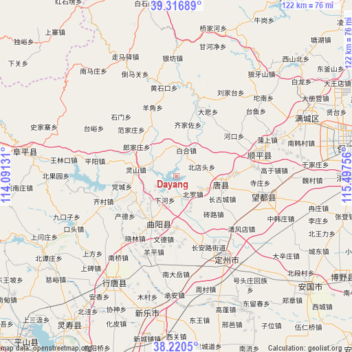
Dayang GPS coordinates[2]
38° 46' 14.88" North, 114° 47' 39.948" East
| Map corner | latitude | longitude |
|---|---|---|
| Upper-left | 39.31689°, | 114.09131° |
| Center: | 38.7708°, | 114.79443° |
| Lower-right: | 38.2205°, | 115.49756° |
| Map W x H: | 121.9×121.9 km | = 75.7×75.7mi |
| max Lat: | 53.31946° ⇑17.8% North |
| Dayang: | 38.7708° |
| min Lat: | ⇓82.2% South 18.22056° |
| min Long | Dayang | max Long |
| 75.07348° | 114.79443° | 134.28917° |
| W 53.1%⇐ | ⇒46.9% E |
Elevation
Elevation of Dayang is 153 m = 502 ft, and this is 331.8 m = 1089 ft below average elevation for this country.
| Max E: |
5622 m = 18445 ft | 51.5% |
| Avg. | 484.8 m = 1591 ft | |
| Dayang | 153 m = 502 ft | |
Min E: |
-3 m = -10 ft | 48.5% |
See also: China elevation on elevation.city.
Geographical zone
Dayang is located in North temperate zone (between Tropic of Cancer and the Arctic Circle). Distance of this Northern Tropic circle is 1705 km =1059.4 mi to South.| Distance of | km | miles | from Dayang |
|---|---|---|---|
| North Pole | 5696.2 | 3539.5 | to North |
| Arctic Circle | 3090.3 | 1920.2 | to North |
| Tropic Cancer | 1705 | 1059.4 | to South |
| Equator | 4310.9 | 2678.7 | to South |


Nearby cities:
15 places around Dayang: (largest is in red/bold)
• Baihe
9.6 km =6 mi,  20°
20°
• Baoshui
6.2 km =3.9 mi,  152°
152°
• Beidiantou
9 km =5.6 mi,  71°
71°
• Beiluo
9.1 km =5.7 mi,  141°
141°
• Changgucheng
16.5 km =10.3 mi,  116°
116°
• Duting
13 km =8.1 mi,  109°
109°
• Langjiazhuang
17.1 km =10.6 mi,  306°
306°
• Lingshan
14 km =8.7 mi,  278°
278°
• Luozhuang
7.7 km =4.8 mi,  183°
183°
• Micheng
10.5 km =6.5 mi,  349°
349°
• Nandiantou
10.5 km =6.5 mi, 121°
• Qijiazuo
18.2 km =11.3 mi,  12°
12°
• Xiahe
9 km =5.6 mi,  207°
207°
• Xiaomu
16.4 km =10.2 mi,  231°
231°
• Zhuangke
12.2 km =7.6 mi, 225°
Sources, notices
• [Note1] Compared only with cities in China existing in our database
• [Src1] Map data: © OpenStreetMap contributors (CC-BY-SA)
• [Src2] Other city data from geonames.org with taken over terms of usage.
• [Src3] Geographical zone / Annual Mean Temperature by Robert A. Rohde @ Wikipedia
