Lingshan geodata
Lingshan (Hebei) is a seat of a fourth-order administrative division; located in China in Asia/Shanghai (GMT+8) time zone. In our database, there are 1268 cities with bigger population. Compared to other cities in China, 82.3% of cities are located further ↓South; 52.2% of cities are located further ←West and 50.3% of cities have higher elevation than Lingshan. Note1


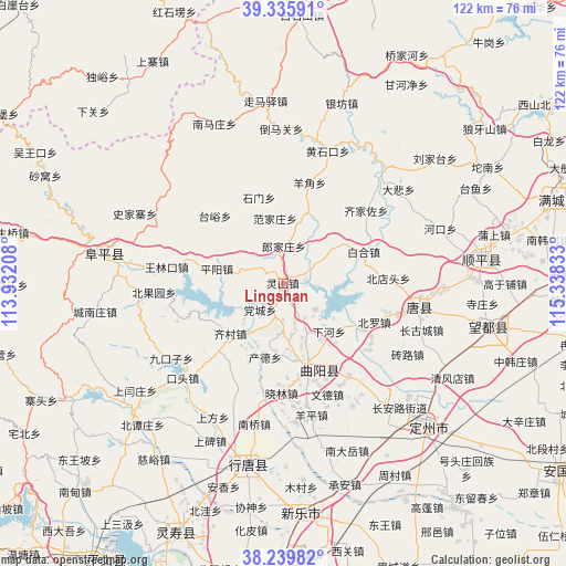
Lingshan GPS coordinates[2]
38° 47' 23.892" North, 114° 38' 6.72" East
| Map corner | latitude | longitude |
|---|---|---|
| Upper-left | 39.33591°, | 113.93208° |
| Center: | 38.78997°, | 114.6352° |
| Lower-right: | 38.23982°, | 115.33833° |
| Map W x H: | 121.9×121.9 km | = 75.7×75.7mi |
| max Lat: | 53.31946° ⇑17.7% North |
| Lingshan: | 38.78997° |
| min Lat: | ⇓82.3% South 18.22056° |
| min Long | Lingshan | max Long |
| 75.07348° | 114.6352° | 134.28917° |
| W 52.2%⇐ | ⇒47.8% E |
Elevation
Elevation of Lingshan is 162 m = 531 ft, and this is 322.8 m = 1059 ft below average elevation for this country.
| Max E: |
5622 m = 18445 ft | 50.3% |
| Avg. | 484.8 m = 1591 ft | |
| Lingshan | 162 m = 531 ft | |
Min E: |
-3 m = -10 ft | 49.7% |
See also: China elevation on elevation.city.
Geographical zone
Lingshan is located in North temperate zone (between Tropic of Cancer and the Arctic Circle). Distance of this Northern Tropic circle is 1707.1 km =1060.7 mi to South.| Distance of | km | miles | from Lingshan |
|---|---|---|---|
| North Pole | 5694 | 3538.1 | to North |
| Arctic Circle | 3088.1 | 1918.9 | to North |
| Tropic Cancer | 1707.1 | 1060.7 | to South |
| Equator | 4313 | 2680 | to South |


Nearby cities:
15 places around Lingshan: (largest is in red/bold)
• Baoshui
18.3 km =11.4 mi,  114°
114°
• Beitai
10 km =6.2 mi,  312°
312°
• Chande
16.6 km =10.3 mi,  195°
195°
• Dangcheng
8.1 km =5 mi,  222°
222°
• Dayang
14 km =8.7 mi,  98°
98°
• Fanjiazhuang
14 km =8.7 mi,  351°
351°
• Juncheng
16.8 km =10.4 mi,  18°
18°
• Langjiazhuang
8.1 km =5 mi,  1°
1°
• Luozhuang
16.5 km =10.3 mi,  126°
126°
• Micheng
14.4 km =8.9 mi,  55°
55°
• Pingyang
14.6 km =9.1 mi,  281°
281°
• Qicun
15.6 km =9.7 mi,  227°
227°
• Xiahe
14 km =8.7 mi,  136°
136°
• Xiaomu
12.4 km =7.7 mi,  175°
175°
• Zhuangke
11.8 km =7.3 mi,  154°
154°
Sources, notices
• [Note1] Compared only with cities in China existing in our database
• [Src1] Map data: © OpenStreetMap contributors (CC-BY-SA)
• [Src2] Other city data from geonames.org with taken over terms of usage.
• [Src3] Geographical zone / Annual Mean Temperature by Robert A. Rohde @ Wikipedia
