Dongyong geodata
Dongyong (Guangdong) is a seat of a fourth-order administrative division; located in China in Asia/Shanghai (GMT+8) time zone. In our database, there are 1268 cities with bigger population. Compared to other cities in China, 95% of cities are located further ↑North; 54.6% of cities are located further →East and 98.9% of cities have higher elevation than Dongyong. Note1


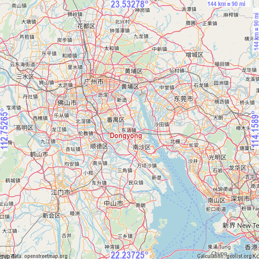
Dongyong GPS coordinates[2]
22° 53' 11.616" North, 113° 27' 20.772" East
| Map corner | latitude | longitude |
|---|---|---|
| Upper-left | 23.53278°, | 112.75265° |
| Center: | 22.88656°, | 113.45577° |
| Lower-right: | 22.23725°, | 114.1589° |
| Map W x H: | 144×144.1 km | = 89.5×89.5mi |
| max Lat: | 53.31946° ⇑95% North |
| Dongyong: | 22.88656° |
| min Lat: | ⇓5% South 18.22056° |
| min Long | Dongyong | max Long |
| 75.07348° | 113.45577° | 134.28917° |
| W 45.4%⇐ | ⇒54.6% E |
Elevation
Elevation of Dongyong is 3 m = 10 ft, and this is 481.8 m = 1581 ft below average elevation for this country.
| Max E: |
5622 m = 18445 ft | 98.9% |
| Avg. | 484.8 m = 1591 ft | |
| Dongyong | 3 m = 10 ft | |
Min E: |
-3 m = -10 ft | 1.1% |
See also: China elevation on elevation.city.
Geographical zone
Dongyong is located in North Torrid zone (between Equator and Tropic of Cancer). Distance of this Northern Tropic circle is 61.2 km =38 mi to North.| Distance of | km | miles | from Dongyong |
|---|---|---|---|
| North Pole | 7462.3 | 4636.9 | to North |
| Arctic Circle | 4856.4 | 3017.6 | to North |
| Tropic Cancer | 61.2 | 38 | to North |
| Equator | 2544.7 | 1581.2 | to South |


Nearby cities:
15 places around Dongyong: (largest is in red/bold)
• Dagang
10.5 km =6.5 mi,  210°
210°
• Dalong
8.4 km =5.2 mi,  339°
339°
• Donghuan
11.1 km =6.9 mi,  305°
305°
• Hengli
17.2 km =10.7 mi,  170°
170°
• Huangge
8.3 km =5.2 mi,  141°
141°
• Lanhe
13 km =8.1 mi,  247°
247°
• Nancun
15.7 km =9.8 mi,  334°
334°
• Nansha
14.7 km =9.1 mi,  128°
128°
• Qiaonan
10.1 km =6.3 mi,  295°
295°
• Shatian
16.5 km =10.3 mi,  75°
75°
• Shatou
14.4 km =8.9 mi, 301°
• Shawan
13 km =8.1 mi,  281°
281°
• Shilou
10.2 km =6.3 mi,  18°
18°
• Shiqi
8.1 km =5 mi, 343°
• Shiqiao
12 km =7.5 mi, 303°
Sources, notices
• [Note1] Compared only with cities in China existing in our database
• [Src1] Map data: © OpenStreetMap contributors (CC-BY-SA)
• [Src2] Other city data from geonames.org with taken over terms of usage.
• [Src3] Geographical zone / Annual Mean Temperature by Robert A. Rohde @ Wikipedia
