Nansha geodata
Nansha (Guangdong) is a seat of a fourth-order administrative division; located in China in Asia/Shanghai (GMT+8) time zone. In our database, there are 1268 cities with bigger population. Compared to other cities in China, 95.3% of cities are located further ↑North; 53.9% of cities are located further →East and 80.2% of cities have higher elevation than Nansha. Note1


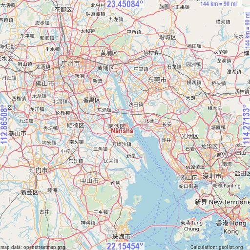
Nansha GPS coordinates[2]
22° 48' 15.228" North, 113° 34' 5.52" East
| Map corner | latitude | longitude |
|---|---|---|
| Upper-left | 23.45084°, | 112.86508° |
| Center: | 22.80423°, | 113.5682° |
| Lower-right: | 22.15454°, | 114.27133° |
| Map W x H: | 144.1×144.1 km | = 89.5×89.5mi |
| max Lat: | 53.31946° ⇑95.3% North |
| Nansha: | 22.80423° |
| min Lat: | ⇓4.7% South 18.22056° |
| min Long | Nansha | max Long |
| 75.07348° | 113.5682° | 134.28917° |
| W 46.1%⇐ | ⇒53.9% E |
Elevation
Elevation of Nansha is 26 m = 85 ft, and this is 458.8 m = 1505 ft below average elevation for this country.
| Max E: |
5622 m = 18445 ft | 80.2% |
| Avg. | 484.8 m = 1591 ft | |
| Nansha | 26 m = 85 ft | |
Min E: |
-3 m = -10 ft | 19.8% |
See also: China elevation on elevation.city.
Geographical zone
Nansha is located in North Torrid zone (between Equator and Tropic of Cancer). Distance of this Northern Tropic circle is 70.3 km =43.7 mi to North.| Distance of | km | miles | from Nansha |
|---|---|---|---|
| North Pole | 7471.5 | 4642.6 | to North |
| Arctic Circle | 4865.6 | 3023.3 | to North |
| Tropic Cancer | 70.3 | 43.7 | to North |
| Equator | 2535.6 | 1575.5 | to South |


Nearby cities:
15 places around Nansha: (largest is in red/bold)
• Dagang
16.9 km =10.5 mi,  270°
270°
• Dalong
22.4 km =13.9 mi,  319°
319°
• Dongyong
14.7 km =9.1 mi,  308°
308°
• Hengli
11.7 km =7.3 mi,  228°
228°
• Hongmei
21.4 km =13.3 mi,  9°
9°
• Houjie
18 km =11.2 mi,  29°
29°
• Huangge
6.9 km =4.3 mi,  293°
293°
• Humen
10.9 km =6.8 mi,  81°
81°
• Minzhong
21.7 km =13.5 mi,  202°
202°
• Sanjiao
19.6 km =12.2 mi, 227°
• Shatian
14 km =8.7 mi,  18°
18°
• Shilou
20.6 km =12.8 mi,  336°
336°
• Shiqi
21.8 km =13.5 mi, 320°
• Wanqingsha
11.1 km =6.9 mi,  192°
192°
• Xinwan
10.4 km =6.5 mi,  100°
100°
Sources, notices
• [Note1] Compared only with cities in China existing in our database
• [Src1] Map data: © OpenStreetMap contributors (CC-BY-SA)
• [Src2] Other city data from geonames.org with taken over terms of usage.
• [Src3] Geographical zone / Annual Mean Temperature by Robert A. Rohde @ Wikipedia
