Huangge geodata
Huangge (Guangdong) is a seat of a fourth-order administrative division; located in China in Asia/Shanghai (GMT+8) time zone. In our database, there are 1268 cities with bigger population. Compared to other cities in China, 95.2% of cities are located further ↑North; 54.3% of cities are located further →East and 86.9% of cities have higher elevation than Huangge. Note1


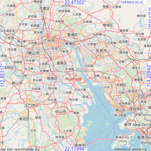
Huangge GPS coordinates[2]
22° 49' 42.672" North, 113° 30' 22.644" East
| Map corner | latitude | longitude |
|---|---|---|
| Upper-left | 23.47502°, | 112.80317° |
| Center: | 22.82852°, | 113.50629° |
| Lower-right: | 22.17894°, | 114.20942° |
| Map W x H: | 144.1×144.1 km | = 89.5×89.5mi |
| max Lat: | 53.31946° ⇑95.2% North |
| Huangge: | 22.82852° |
| min Lat: | ⇓4.8% South 18.22056° |
| min Long | Huangge | max Long |
| 75.07348° | 113.50629° | 134.28917° |
| W 45.7%⇐ | ⇒54.3% E |
Elevation
Elevation of Huangge is 13 m = 43 ft, and this is 471.8 m = 1548 ft below average elevation for this country.
| Max E: |
5622 m = 18445 ft | 86.9% |
| Avg. | 484.8 m = 1591 ft | |
| Huangge | 13 m = 43 ft | |
Min E: |
-3 m = -10 ft | 13.1% |
See also: China elevation on elevation.city.
Geographical zone
Huangge is located in North Torrid zone (between Equator and Tropic of Cancer). Distance of this Northern Tropic circle is 67.6 km =42 mi to North.| Distance of | km | miles | from Huangge |
|---|---|---|---|
| North Pole | 7468.8 | 4640.9 | to North |
| Arctic Circle | 4862.9 | 3021.7 | to North |
| Tropic Cancer | 67.6 | 42 | to North |
| Equator | 2538.3 | 1577.2 | to South |


Nearby cities:
15 places around Huangge: (largest is in red/bold)
• Dagang
10.8 km =6.7 mi,  256°
256°
• Dalong
16.5 km =10.3 mi,  330°
330°
• Donghuan
19.2 km =11.9 mi,  312°
312°
• Dongyong
8.3 km =5.2 mi,  321°
321°
• Hengli
10.8 km =6.7 mi,  192°
192°
• Humen
17.1 km =10.6 mi,  93°
93°
• Lanhe
17.3 km =10.7 mi,  275°
275°
• Nansha
6.9 km =4.3 mi,  113°
113°
• Qiaonan
17.9 km =11.1 mi, 306°
• Sanjiao
17.9 km =11.1 mi,  206°
206°
• Shatian
15.1 km =9.4 mi,  45°
45°
• Shilou
16.2 km =10.1 mi,  353°
353°
• Shiqi
16.1 km =10 mi, 332°
• Wanqingsha
14.1 km =8.8 mi,  163°
163°
• Xinwan
17.2 km =10.7 mi, 105°
Sources, notices
• [Note1] Compared only with cities in China existing in our database
• [Src1] Map data: © OpenStreetMap contributors (CC-BY-SA)
• [Src2] Other city data from geonames.org with taken over terms of usage.
• [Src3] Geographical zone / Annual Mean Temperature by Robert A. Rohde @ Wikipedia
