Dajiang geodata
Dajiang (Guangdong) is a seat of a fourth-order administrative division; located in China in Asia/Shanghai (GMT+8) time zone. In our database, there are 1268 cities with bigger population. Compared to other cities in China, 96.4% of cities are located further ↑North; 62.1% of cities are located further →East and 56% of cities have higher elevation than Dajiang. Note1


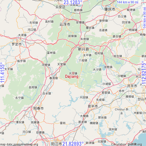
Dajiang GPS coordinates[2]
22° 28' 48.504" North, 112° 7' 7.032" East
| Map corner | latitude | longitude |
|---|---|---|
| Upper-left | 23.1283°, | 111.4155° |
| Center: | 22.48014°, | 112.11862° |
| Lower-right: | 21.82893°, | 112.82175° |
| Map W x H: | 144.5×144.5 km | = 89.8×89.8mi |
| max Lat: | 53.31946° ⇑96.4% North |
| Dajiang: | 22.48014° |
| min Lat: | ⇓3.6% South 18.22056° |
| min Long | Dajiang | max Long |
| 75.07348° | 112.11862° | 134.28917° |
| W 37.9%⇐ | ⇒62.1% E |
Elevation
Elevation of Dajiang is 124 m = 407 ft, and this is 360.8 m = 1184 ft below average elevation for this country.
| Max E: |
5622 m = 18445 ft | 56% |
| Avg. | 484.8 m = 1591 ft | |
| Dajiang | 124 m = 407 ft | |
Min E: |
-3 m = -10 ft | 44% |
See also: China elevation on elevation.city.
Geographical zone
Dajiang is located in North Torrid zone (between Equator and Tropic of Cancer). Distance of this Northern Tropic circle is 106.4 km =66.1 mi to North.| Distance of | km | miles | from Dajiang |
|---|---|---|---|
| North Pole | 7507.5 | 4664.9 | to North |
| Arctic Circle | 4901.6 | 3045.7 | to North |
| Tropic Cancer | 106.4 | 66.1 | to North |
| Equator | 2499.6 | 1553.2 | to South |


Nearby cities:
15 places around Dajiang: (largest is in red/bold)
• Chunwan
19.8 km =12.3 mi,  256°
256°
• Dasha
23.6 km =14.7 mi,  79°
79°
• Datian
26.4 km =16.4 mi,  155°
155°
• Helang
28.1 km =17.5 mi,  287°
287°
• Hetou
14 km =8.7 mi,  326°
326°
• Lezhu
23.9 km =14.9 mi,  359°
359°
• Liangxi
28.5 km =17.7 mi,  128°
128°
• Lidong
6.6 km =4.1 mi,  102°
102°
• Liuzu
16.4 km =10.2 mi,  36°
36°
• Niujiang
29.2 km =18.1 mi,  113°
113°
• Shiwang
20.2 km =12.6 mi,  284°
284°
• Songbai
24.4 km =15.2 mi,  270°
270°
• Taiping
21.7 km =13.5 mi,  34°
34°
• Tiantang
15.2 km =9.4 mi,  306°
306°
• Xincheng
26.9 km =16.7 mi,  23°
23°
Sources, notices
• [Note1] Compared only with cities in China existing in our database
• [Src1] Map data: © OpenStreetMap contributors (CC-BY-SA)
• [Src2] Other city data from geonames.org with taken over terms of usage.
• [Src3] Geographical zone / Annual Mean Temperature by Robert A. Rohde @ Wikipedia
