Shiwang geodata
Shiwang (Guangdong) is a seat of a fourth-order administrative division; located in China in Asia/Shanghai (GMT+8) time zone. In our database, there are 1268 cities with bigger population. Compared to other cities in China, 96.3% of cities are located further ↑North; 63% of cities are located further →East and 62.3% of cities have higher elevation than Shiwang. Note1


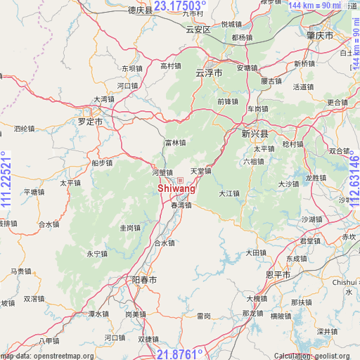
Shiwang GPS coordinates[2]
22° 31' 37.524" North, 111° 55' 41.988" East
| Map corner | latitude | longitude |
|---|---|---|
| Upper-left | 23.17503°, | 111.22521° |
| Center: | 22.52709°, | 111.92833° |
| Lower-right: | 21.8761°, | 112.63146° |
| Map W x H: | 144.4×144.4 km | = 89.7×89.7mi |
| max Lat: | 53.31946° ⇑96.3% North |
| Shiwang: | 22.52709° |
| min Lat: | ⇓3.7% South 18.22056° |
| min Long | Shiwang | max Long |
| 75.07348° | 111.92833° | 134.28917° |
| W 37%⇐ | ⇒63% E |
Elevation
Elevation of Shiwang is 86 m = 282 ft, and this is 398.8 m = 1308 ft below average elevation for this country.
| Max E: |
5622 m = 18445 ft | 62.3% |
| Avg. | 484.8 m = 1591 ft | |
| Shiwang | 86 m = 282 ft | |
Min E: |
-3 m = -10 ft | 37.7% |
See also: China elevation on elevation.city.
Geographical zone
Shiwang is located in North Torrid zone (between Equator and Tropic of Cancer). Distance of this Northern Tropic circle is 101.1 km =62.8 mi to North.| Distance of | km | miles | from Shiwang |
|---|---|---|---|
| North Pole | 7502.3 | 4661.7 | to North |
| Arctic Circle | 4896.4 | 3042.5 | to North |
| Tropic Cancer | 101.1 | 62.8 | to North |
| Equator | 2504.8 | 1556.4 | to South |


Nearby cities:
15 places around Shiwang: (largest is in red/bold)
• Bingtang
25.3 km =15.7 mi,  295°
295°
• Chunwan
9.8 km =6.1 mi,  178°
178°
• Dajiang
20.2 km =12.6 mi,  104°
104°
• Fulin
15.4 km =9.6 mi,  347°
347°
• Guigang
27.7 km =17.2 mi,  226°
226°
• Helang
8 km =5 mi,  294°
294°
• Heshui
25.8 km =16 mi,  194°
194°
• Hetou
13.4 km =8.3 mi,  61°
61°
• Jinji
23.5 km =14.6 mi,  332°
332°
• Lezhu
26.7 km =16.6 mi,  45°
45°
• Lidong
26.9 km =16.7 mi, 104°
• Liuzu
30.4 km =18.9 mi,  74°
74°
• Pimian
22 km =13.7 mi,  202°
202°
• Songbai
7.1 km =4.4 mi,  223°
223°
• Tiantang
8.3 km =5.2 mi, 62°
Sources, notices
• [Note1] Compared only with cities in China existing in our database
• [Src1] Map data: © OpenStreetMap contributors (CC-BY-SA)
• [Src2] Other city data from geonames.org with taken over terms of usage.
• [Src3] Geographical zone / Annual Mean Temperature by Robert A. Rohde @ Wikipedia
