Gaofeng geodata
Gaofeng (Guangdong) is a seat of a fourth-order administrative division; located in China in Asia/Shanghai (GMT+8) time zone. In our database, there are 1268 cities with bigger population. Compared to other cities in China, 94.7% of cities are located further ↑North; 62.5% of cities are located further →East and 58.2% of cities have higher elevation than Gaofeng. Note1


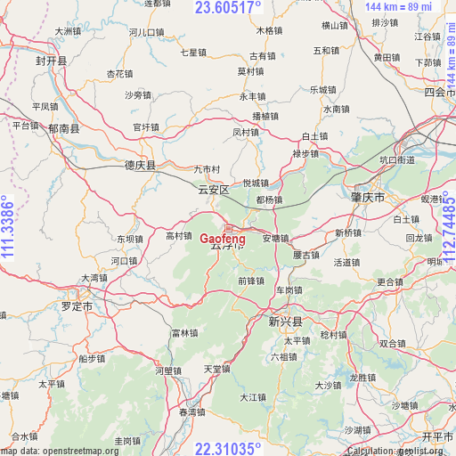
Gaofeng GPS coordinates[2]
22° 57' 33.516" North, 112° 2' 30.192" East
| Map corner | latitude | longitude |
|---|---|---|
| Upper-left | 23.60517°, | 111.3386° |
| Center: | 22.95931°, | 112.04172° |
| Lower-right: | 22.31035°, | 112.74485° |
| Map W x H: | 144×144 km | = 89.5×89.5mi |
| max Lat: | 53.31946° ⇑94.7% North |
| Gaofeng: | 22.95931° |
| min Lat: | ⇓5.3% South 18.22056° |
| min Long | Gaofeng | max Long |
| 75.07348° | 112.04172° | 134.28917° |
| W 37.5%⇐ | ⇒62.5% E |
Elevation
Elevation of Gaofeng is 110 m = 361 ft, and this is 374.8 m = 1230 ft below average elevation for this country.
| Max E: |
5622 m = 18445 ft | 58.2% |
| Avg. | 484.8 m = 1591 ft | |
| Gaofeng | 110 m = 361 ft | |
Min E: |
-3 m = -10 ft | 41.8% |
See also: China elevation on elevation.city.
Geographical zone
Gaofeng is located in North Torrid zone (between Equator and Tropic of Cancer). Distance of this Northern Tropic circle is 53.1 km =33 mi to North.| Distance of | km | miles | from Gaofeng |
|---|---|---|---|
| North Pole | 7454.2 | 4631.8 | to North |
| Arctic Circle | 4848.3 | 3012.6 | to North |
| Tropic Cancer | 53.1 | 33 | to North |
| Equator | 2552.8 | 1586.2 | to South |


Nearby cities:
15 places around Gaofeng: (largest is in red/bold)
• Antang
16.8 km =10.4 mi,  101°
101°
• Baishi
29.6 km =18.4 mi,  238°
238°
• Chegang
28.4 km =17.6 mi,  135°
135°
• Duyang
12.8 km =8 mi,  59°
59°
• Gaocun
15.8 km =9.8 mi,  263°
263°
• Hekou
7.1 km =4.4 mi,  85°
85°
• Jiushi
21.1 km =13.1 mi,  339°
339°
• Liudu
13.7 km =8.5 mi, 343°
• Nansheng
14.7 km =9.1 mi,  171°
171°
• Silao
19.1 km =11.9 mi, 99°
• Songgui
29.2 km =18.1 mi, 257°
• Yaogu
25.7 km =16 mi,  106°
106°
• Yuecheng
17.2 km =10.7 mi,  31°
31°
• Yuncheng
2.1 km =1.3 mi,  157°
157°
• Yunfu
3.5 km =2.2 mi,  183°
183°
Sources, notices
• [Note1] Compared only with cities in China existing in our database
• [Src1] Map data: © OpenStreetMap contributors (CC-BY-SA)
• [Src2] Other city data from geonames.org with taken over terms of usage.
• [Src3] Geographical zone / Annual Mean Temperature by Robert A. Rohde @ Wikipedia
