Duyang geodata
Duyang (Guangdong) is a seat of a fourth-order administrative division; located in China in Asia/Shanghai (GMT+8) time zone. In our database, there are 1268 cities with bigger population. Compared to other cities in China, 94.4% of cities are located further ↑North; 62% of cities are located further →East and 82.9% of cities have higher elevation than Duyang. Note1


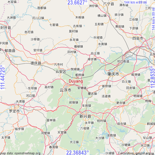
Duyang GPS coordinates[2]
23° 1' 1.632" North, 112° 9' 1.332" East
| Map corner | latitude | longitude |
|---|---|---|
| Upper-left | 23.6627°, | 111.44725° |
| Center: | 23.01712°, | 112.15037° |
| Lower-right: | 22.36843°, | 112.8535° |
| Map W x H: | 143.9×143.9 km | = 89.4×89.4mi |
| max Lat: | 53.31946° ⇑94.4% North |
| Duyang: | 23.01712° |
| min Lat: | ⇓5.6% South 18.22056° |
| min Long | Duyang | max Long |
| 75.07348° | 112.15037° | 134.28917° |
| W 38%⇐ | ⇒62% E |
Elevation
Elevation of Duyang is 20 m = 66 ft, and this is 464.8 m = 1525 ft below average elevation for this country.
| Max E: |
5622 m = 18445 ft | 82.9% |
| Avg. | 484.8 m = 1591 ft | |
| Duyang | 20 m = 66 ft | |
Min E: |
-3 m = -10 ft | 17.1% |
See also: China elevation on elevation.city.
Geographical zone
Duyang is located in North Torrid zone (between Equator and Tropic of Cancer). Distance of this Northern Tropic circle is 46.7 km =29 mi to North.| Distance of | km | miles | from Duyang |
|---|---|---|---|
| North Pole | 7447.8 | 4627.8 | to North |
| Arctic Circle | 4841.9 | 3008.6 | to North |
| Tropic Cancer | 46.7 | 29 | to North |
| Equator | 2559.3 | 1590.3 | to South |


Nearby cities:
15 places around Duyang: (largest is in red/bold)
• Antang
11.1 km =6.9 mi,  151°
151°
• Baizhu
21.2 km =13.2 mi,  110°
110°
• Dawan
25.5 km =15.8 mi,  82°
82°
• Fengcun
24.7 km =15.3 mi,  346°
346°
• Gaofeng
12.8 km =8 mi,  239°
239°
• Hekou
7.2 km =4.5 mi,  214°
214°
• Jiushi
22.8 km =14.2 mi,  305°
305°
• Liudu
16.5 km =10.3 mi,  293°
293°
• Lubu
21.9 km =13.6 mi,  38°
38°
• Nansheng
22.9 km =14.2 mi,  203°
203°
• Silao
12.4 km =7.7 mi,  141°
141°
• Yaogu
19.3 km =12 mi, 135°
• Yuecheng
8.6 km =5.3 mi,  344°
344°
• Yuncheng
13.3 km =8.3 mi,  231°
231°
• Yunfu
15 km =9.3 mi, 228°
Sources, notices
• [Note1] Compared only with cities in China existing in our database
• [Src1] Map data: © OpenStreetMap contributors (CC-BY-SA)
• [Src2] Other city data from geonames.org with taken over terms of usage.
• [Src3] Geographical zone / Annual Mean Temperature by Robert A. Rohde @ Wikipedia
