Fengpo geodata
Fengpo (Hainan) is a seat of a fourth-order administrative division; located in China in Asia/Shanghai (GMT+8) time zone. In our database, there are 1268 cities with bigger population. Compared to other cities in China, 98.8% of cities are located further ↑North; 68% of cities are located further →East and 86.9% of cities have higher elevation than Fengpo. Note1


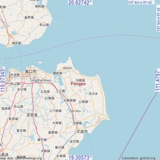
Fengpo GPS coordinates[2]
19° 58' 4.656" North, 110° 46' 35.652" East
| Map corner | latitude | longitude |
|---|---|---|
| Upper-left | 20.62742°, | 110.07345° |
| Center: | 19.96796°, | 110.77657° |
| Lower-right: | 19.30573°, | 111.4797° |
| Map W x H: | 147×147 km | = 91.3×91.3mi |
| max Lat: | 53.31946° ⇑98.8% North |
| Fengpo: | 19.96796° |
| min Lat: | ⇓1.2% South 18.22056° |
| min Long | Fengpo | max Long |
| 75.07348° | 110.77657° | 134.28917° |
| W 32%⇐ | ⇒68% E |
Elevation
Elevation of Fengpo is 13 m = 43 ft, and this is 471.8 m = 1548 ft below average elevation for this country.
| Max E: |
5622 m = 18445 ft | 86.9% |
| Avg. | 484.8 m = 1591 ft | |
| Fengpo | 13 m = 43 ft | |
Min E: |
-3 m = -10 ft | 13.1% |
See also: China elevation on elevation.city.
Geographical zone
Fengpo is located in North Torrid zone (between Equator and Tropic of Cancer). Distance of this Northern Tropic circle is 385.7 km =239.7 mi to North.| Distance of | km | miles | from Fengpo |
|---|---|---|---|
| North Pole | 7786.8 | 4838.5 | to North |
| Arctic Circle | 5180.9 | 3219.3 | to North |
| Tropic Cancer | 385.7 | 239.7 | to North |
| Equator | 2220.2 | 1379.6 | to South |


Nearby cities:
15 places around Fengpo: (largest is in red/bold)
• Baoluo
14.5 km =9 mi,  193°
193°
• Changsa
26.1 km =16.2 mi,  150°
150°
• Dazhipo
20.8 km =12.9 mi,  208°
208°
• Dongge
35 km =21.7 mi,  168°
168°
• Donglu
27.5 km =17.1 mi,  202°
202°
• Gongpo
19.8 km =12.3 mi, 171°
• Hongqi
32.7 km =20.3 mi,  239°
239°
• Jinshan
9.7 km =6 mi,  290°
290°
• Puqian
21.8 km =13.5 mi, 287°
• Sanjiang
20.8 km =12.9 mi, 242°
• Tanniu
28.9 km =18 mi, 189°
• Wengtian
10.8 km =6.7 mi,  111°
111°
• Wenjiao
35.8 km =22.2 mi,  157°
157°
• Yanfeng
24.1 km =15 mi,  266°
266°
• Yunlong
33.9 km =21.1 mi,  252°
252°
Sources, notices
• [Note1] Compared only with cities in China existing in our database
• [Src1] Map data: © OpenStreetMap contributors (CC-BY-SA)
• [Src2] Other city data from geonames.org with taken over terms of usage.
• [Src3] Geographical zone / Annual Mean Temperature by Robert A. Rohde @ Wikipedia
