Dongge geodata
Dongge (Hainan) is a seat of a fourth-order administrative division; located in China in Asia/Shanghai (GMT+8) time zone. In our database, there are 1268 cities with bigger population. Compared to other cities in China, 99.1% of cities are located further ↑North; 67.7% of cities are located further →East and 82.4% of cities have higher elevation than Dongge. Note1


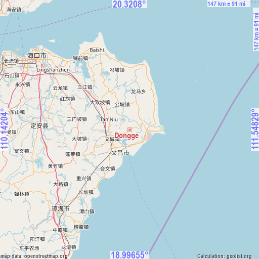
Dongge GPS coordinates[2]
19° 39' 36.144" North, 110° 50' 42.576" East
| Map corner | latitude | longitude |
|---|---|---|
| Upper-left | 20.3208°, | 110.14204° |
| Center: | 19.66004°, | 110.84516° |
| Lower-right: | 18.99655°, | 111.54829° |
| Map W x H: | 147.2×147.2 km | = 91.5×91.5mi |
| max Lat: | 53.31946° ⇑99.1% North |
| Dongge: | 19.66004° |
| min Lat: | ⇓0.9% South 18.22056° |
| min Long | Dongge | max Long |
| 75.07348° | 110.84516° | 134.28917° |
| W 32.3%⇐ | ⇒67.7% E |
Elevation
Elevation of Dongge is 21 m = 69 ft, and this is 463.8 m = 1522 ft below average elevation for this country.
| Max E: |
5622 m = 18445 ft | 82.4% |
| Avg. | 484.8 m = 1591 ft | |
| Dongge | 21 m = 69 ft | |
Min E: |
-3 m = -10 ft | 17.6% |
See also: China elevation on elevation.city.
Geographical zone
Dongge is located in North Torrid zone (between Equator and Tropic of Cancer). Distance of this Northern Tropic circle is 419.9 km =260.9 mi to North.| Distance of | km | miles | from Dongge |
|---|---|---|---|
| North Pole | 7821.1 | 4859.8 | to North |
| Arctic Circle | 5215.2 | 3240.6 | to North |
| Tropic Cancer | 419.9 | 260.9 | to North |
| Equator | 2186 | 1358.3 | to South |


Nearby cities:
15 places around Dongge: (largest is in red/bold)
• Baoluo
22.7 km =14.1 mi,  332°
332°
• Changsa
12.7 km =7.9 mi,  25°
25°
• Dapo
29.1 km =18.1 mi,  260°
260°
• Dazhipo
23.3 km =14.5 mi,  312°
312°
• Dongjiao
9.3 km =5.8 mi,  172°
172°
• Donglu
19.6 km =12.2 mi,  296°
296°
• Fengpo
35 km =21.7 mi,  348°
348°
• Gongpo
15.3 km =9.5 mi,  343°
343°
• Huiwen
25.3 km =15.7 mi,  210°
210°
• Longlou
12.5 km =7.8 mi,  91°
91°
• Sanmenpo
30.7 km =19.1 mi,  281°
281°
• Tanniu
13.3 km =8.3 mi, 295°
• Wenchang
11.2 km =7 mi,  243°
243°
• Wengtian
30.5 km =19 mi,  5°
5°
• Wenjiao
6.5 km =4 mi,  80°
80°
Sources, notices
• [Note1] Compared only with cities in China existing in our database
• [Src1] Map data: © OpenStreetMap contributors (CC-BY-SA)
• [Src2] Other city data from geonames.org with taken over terms of usage.
• [Src3] Geographical zone / Annual Mean Temperature by Robert A. Rohde @ Wikipedia
