Baoluo geodata
Baoluo (Hainan) is a seat of a fourth-order administrative division; located in China in Asia/Shanghai (GMT+8) time zone. In our database, there are 1268 cities with bigger population. Compared to other cities in China, 98.9% of cities are located further ↑North; 68.1% of cities are located further →East and 74.1% of cities have higher elevation than Baoluo. Note1


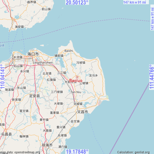
Baoluo GPS coordinates[2]
19° 50' 28.428" North, 110° 44' 40.308" East
| Map corner | latitude | longitude |
|---|---|---|
| Upper-left | 20.50123°, | 110.04141° |
| Center: | 19.84123°, | 110.74453° |
| Lower-right: | 19.17848°, | 111.44766° |
| Map W x H: | 147.1×147.1 km | = 91.4×91.4mi |
| max Lat: | 53.31946° ⇑98.9% North |
| Baoluo: | 19.84123° |
| min Lat: | ⇓1.1% South 18.22056° |
| min Long | Baoluo | max Long |
| 75.07348° | 110.74453° | 134.28917° |
| W 31.9%⇐ | ⇒68.1% E |
Elevation
Elevation of Baoluo is 39 m = 128 ft, and this is 445.8 m = 1463 ft below average elevation for this country.
| Max E: |
5622 m = 18445 ft | 74.1% |
| Avg. | 484.8 m = 1591 ft | |
| Baoluo | 39 m = 128 ft | |
Min E: |
-3 m = -10 ft | 25.9% |
See also: China elevation on elevation.city.
Geographical zone
Baoluo is located in North Torrid zone (between Equator and Tropic of Cancer). Distance of this Northern Tropic circle is 399.8 km =248.4 mi to North.| Distance of | km | miles | from Baoluo |
|---|---|---|---|
| North Pole | 7800.9 | 4847.3 | to North |
| Arctic Circle | 5195 | 3228 | to North |
| Tropic Cancer | 399.8 | 248.4 | to North |
| Equator | 2206.1 | 1370.8 | to South |


Nearby cities:
15 places around Baoluo: (largest is in red/bold)
• Changsa
18.3 km =11.4 mi,  118°
118°
• Dazhipo
7.8 km =4.8 mi,  237°
237°
• Dongge
22.7 km =14.1 mi,  152°
152°
• Donglu
13.4 km =8.3 mi,  211°
211°
• Fengpo
14.5 km =9 mi,  13°
13°
• Gongpo
8.2 km =5.1 mi,  131°
131°
• Hongqi
25 km =15.5 mi,  264°
264°
• Jinshan
18.4 km =11.4 mi,  341°
341°
• Sanjiang
15.6 km =9.7 mi,  286°
286°
• Sanmenpo
23.9 km =14.9 mi,  234°
234°
• Tanniu
14.5 km =9 mi,  185°
185°
• Wenchang
25.1 km =15.6 mi,  178°
178°
• Wengtian
16.9 km =10.5 mi,  52°
52°
• Wenjiao
25.5 km =15.8 mi,  138°
138°
• Yanfeng
24.3 km =15.1 mi,  301°
301°
Sources, notices
• [Note1] Compared only with cities in China existing in our database
• [Src1] Map data: © OpenStreetMap contributors (CC-BY-SA)
• [Src2] Other city data from geonames.org with taken over terms of usage.
• [Src3] Geographical zone / Annual Mean Temperature by Robert A. Rohde @ Wikipedia
