Yuanyang geodata
Yuanyang (Chongqing) is a seat of a fourth-order administrative division; located in China in Asia/Shanghai (GMT+8) time zone. In our database, there are 1268 cities with bigger population. Compared to other cities in China, 57.8% of cities are located further ↑North; 85% of cities are located further →East and 68.3% of cities have lower elevation than Yuanyang. Note1


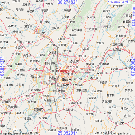
Yuanyang GPS coordinates[2]
29° 39' 56.592" North, 106° 33' 26.964" East
| Map corner | latitude | longitude |
|---|---|---|
| Upper-left | 30.27482°, | 105.85437° |
| Center: | 29.66572°, | 106.55749° |
| Lower-right: | 29.05291°, | 107.26062° |
| Map W x H: | 135.9×135.9 km | = 84.4×84.4mi |
| max Lat: | 53.31946° ⇑57.8% North |
| Yuanyang: | 29.66572° |
| min Lat: | ⇓42.2% South 18.22056° |
| min Long | Yuanyang | max Long |
| 75.07348° | 106.55749° | 134.28917° |
| W 15%⇐ | ⇒85% E |
Elevation
Elevation of Yuanyang is 381 m = 1250 ft, and this is 103.8 m = 341 ft below average elevation for this country.
| Max E: |
5622 m = 18445 ft | 31.7% |
| Avg. | 484.8 m = 1591 ft | |
| Yuanyang | 381 m = 1250 ft | |
Min E: |
-3 m = -10 ft | 68.3% |
See also: China elevation on elevation.city.
Geographical zone
Yuanyang is located in North temperate zone (between Tropic of Cancer and the Arctic Circle). Distance of this Northern Tropic circle is 692.6 km =430.4 mi to South.| Distance of | km | miles | from Yuanyang |
|---|---|---|---|
| North Pole | 6708.5 | 4168.5 | to North |
| Arctic Circle | 4102.7 | 2549.3 | to North |
| Tropic Cancer | 692.6 | 430.4 | to South |
| Equator | 3298.5 | 2049.6 | to South |


Nearby cities:
15 places around Yuanyang: (largest is in red/bold)
• Caijiagang
11.7 km =7.3 mi,  316°
316°
• Chongqing
11.5 km =7.1 mi,  182°
182°
• Cuntan
7.1 km =4.4 mi,  169°
169°
• Dazhulin
10.1 km =6.3 mi,  245°
245°
• Fuxing
17 km =10.6 mi,  359°
359°
• Huixing
5.9 km =3.7 mi,  69°
69°
• Jiguanshi
9.1 km =5.7 mi,  149°
149°
• Lijia
6.4 km =4 mi,  283°
283°
• Nanping
14.2 km =8.8 mi, 168°
• Renhe
5.5 km =3.4 mi,  213°
213°
• Shijialiang
15.9 km =9.9 mi,  328°
328°
• Shuangfengqiao
8.9 km =5.5 mi,  48°
48°
• Shuitu
14.2 km =8.8 mi,  335°
335°
• Tongjiaxi
11.1 km =6.9 mi, 281°
• Yufengshan
10.5 km =6.5 mi,  91°
91°
Sources, notices
• [Note1] Compared only with cities in China existing in our database
• [Src1] Map data: © OpenStreetMap contributors (CC-BY-SA)
• [Src2] Other city data from geonames.org with taken over terms of usage.
• [Src3] Geographical zone / Annual Mean Temperature by Robert A. Rohde @ Wikipedia
