Zhouzai geodata
Zhouzai (Guangdong) is a seat of a fourth-order administrative division; located in China in Asia/Shanghai (GMT+8) time zone. In our database, there are 1268 cities with bigger population. Compared to other cities in China, 91.7% of cities are located further ↑North; 61.2% of cities are located further →East and 58.5% of cities have higher elevation than Zhouzai. Note1


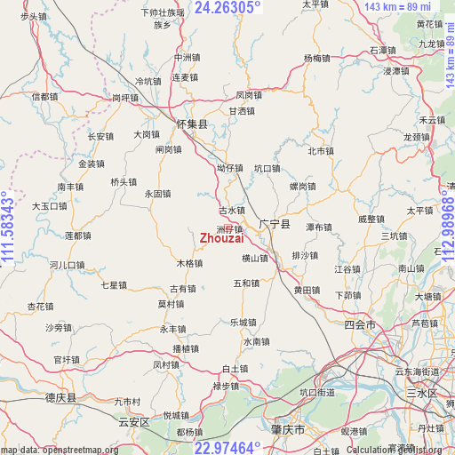
Zhouzai GPS coordinates[2]
23° 37' 13.548" North, 112° 17' 11.58" East
| Map corner | latitude | longitude |
|---|---|---|
| Upper-left | 24.26305°, | 111.58343° |
| Center: | 23.62043°, | 112.28655° |
| Lower-right: | 22.97464°, | 112.98968° |
| Map W x H: | 143.3×143.3 km | = 89×89mi |
| max Lat: | 53.31946° ⇑91.7% North |
| Zhouzai: | 23.62043° |
| min Lat: | ⇓8.3% South 18.22056° |
| min Long | Zhouzai | max Long |
| 75.07348° | 112.28655° | 134.28917° |
| W 38.8%⇐ | ⇒61.2% E |
Elevation
Elevation of Zhouzai is 108 m = 354 ft, and this is 376.8 m = 1236 ft below average elevation for this country.
| Max E: |
5622 m = 18445 ft | 58.5% |
| Avg. | 484.8 m = 1591 ft | |
| Zhouzai | 108 m = 354 ft | |
Min E: |
-3 m = -10 ft | 41.5% |
See also: China elevation on elevation.city.
Geographical zone
Zhouzai is located in North temperate zone (between Tropic of Cancer and the Arctic Circle). Distance of this Northern Tropic circle is 20.4 km =12.7 mi to South.| Distance of | km | miles | from Zhouzai |
|---|---|---|---|
| North Pole | 7380.7 | 4586.2 | to North |
| Arctic Circle | 4774.8 | 2966.9 | to North |
| Tropic Cancer | 20.4 | 12.7 | to South |
| Equator | 2626.3 | 1631.9 | to South |


Nearby cities:
15 places around Zhouzai: (largest is in red/bold)
• Aozai
19.2 km =11.9 mi,  5°
5°
• Binheng
21.6 km =13.4 mi,  140°
140°
• Gushui
7.5 km =4.7 mi, 11°
• Hengshan
13.2 km =8.2 mi, 138°
• Kengkou
21.9 km =13.6 mi,  31°
31°
• Luogang
25.8 km =16 mi,  61°
61°
• Muge
16.4 km =10.2 mi,  225°
225°
• Nanjie
15.2 km =9.4 mi,  84°
84°
• Paisha
26.3 km =16.3 mi,  110°
110°
• Shidong
22.3 km =13.9 mi,  270°
270°
• Shijian
21 km =13 mi,  123°
123°
• Shizui
13 km =8.1 mi, 268°
• Tanbu
27.8 km =17.3 mi,  89°
89°
• Wuhe
20.1 km =12.5 mi,  162°
162°
• Yonggu
24.5 km =15.2 mi,  295°
295°
Sources, notices
• [Note1] Compared only with cities in China existing in our database
• [Src1] Map data: © OpenStreetMap contributors (CC-BY-SA)
• [Src2] Other city data from geonames.org with taken over terms of usage.
• [Src3] Geographical zone / Annual Mean Temperature by Robert A. Rohde @ Wikipedia
