Gushui geodata
Gushui (Guangdong) is a seat of a fourth-order administrative division; located in China in Asia/Shanghai (GMT+8) time zone. In our database, there are 1268 cities with bigger population. Compared to other cities in China, 91.4% of cities are located further ↑North; 61.1% of cities are located further →East and 58.1% of cities have higher elevation than Gushui. Note1


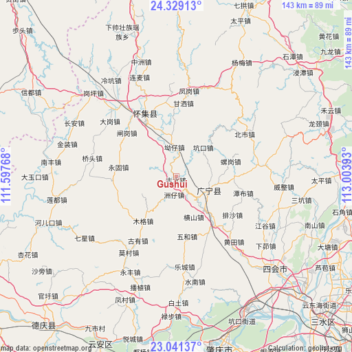
Gushui GPS coordinates[2]
23° 41' 12.624" North, 112° 18' 2.88" East
| Map corner | latitude | longitude |
|---|---|---|
| Upper-left | 24.32913°, | 111.59768° |
| Center: | 23.68684°, | 112.3008° |
| Lower-right: | 23.04137°, | 113.00393° |
| Map W x H: | 143.2×143.2 km | = 89×89mi |
| max Lat: | 53.31946° ⇑91.4% North |
| Gushui: | 23.68684° |
| min Lat: | ⇓8.6% South 18.22056° |
| min Long | Gushui | max Long |
| 75.07348° | 112.3008° | 134.28917° |
| W 38.9%⇐ | ⇒61.1% E |
Elevation
Elevation of Gushui is 111 m = 364 ft, and this is 373.8 m = 1226 ft below average elevation for this country.
| Max E: |
5622 m = 18445 ft | 58.1% |
| Avg. | 484.8 m = 1591 ft | |
| Gushui | 111 m = 364 ft | |
Min E: |
-3 m = -10 ft | 41.9% |
See also: China elevation on elevation.city.
Geographical zone
Gushui is located in North temperate zone (between Tropic of Cancer and the Arctic Circle). Distance of this Northern Tropic circle is 27.8 km =17.3 mi to South.| Distance of | km | miles | from Gushui |
|---|---|---|---|
| North Pole | 7373.3 | 4581.6 | to North |
| Arctic Circle | 4767.4 | 2962.3 | to North |
| Tropic Cancer | 27.8 | 17.3 | to South |
| Equator | 2633.7 | 1636.5 | to South |


Nearby cities:
15 places around Gushui: (largest is in red/bold)
• Aozai
11.8 km =7.3 mi,  2°
2°
• Binheng
27 km =16.8 mi,  152°
152°
• Chikeng
25.6 km =15.9 mi,  44°
44°
• Hengshan
18.8 km =11.7 mi,  157°
157°
• Kengkou
15.1 km =9.4 mi, 41°
• Luogang
21.8 km =13.5 mi,  77°
77°
• Muge
23 km =14.3 mi,  215°
215°
• Nanjie
14.8 km =9.2 mi,  113°
113°
• Shidong
24.9 km =15.5 mi,  252°
252°
• Shijian
24.8 km =15.4 mi,  139°
139°
• Shizui
16.4 km =10.2 mi,  242°
242°
• Wuhe
27 km =16.8 mi,  170°
170°
• Yonggu
23.8 km =14.8 mi,  277°
277°
• Zhagang
26 km =16.2 mi,  308°
308°
• Zhouzai
7.5 km =4.7 mi,  191°
191°
Sources, notices
• [Note1] Compared only with cities in China existing in our database
• [Src1] Map data: © OpenStreetMap contributors (CC-BY-SA)
• [Src2] Other city data from geonames.org with taken over terms of usage.
• [Src3] Geographical zone / Annual Mean Temperature by Robert A. Rohde @ Wikipedia
