Kengkou geodata
Kengkou (Guangdong) is a seat of a fourth-order administrative division; located in China in Asia/Shanghai (GMT+8) time zone. In our database, there are 1268 cities with bigger population. Compared to other cities in China, 91% of cities are located further ↑North; 60.6% of cities are located further →East and 54.2% of cities have higher elevation than Kengkou. Note1


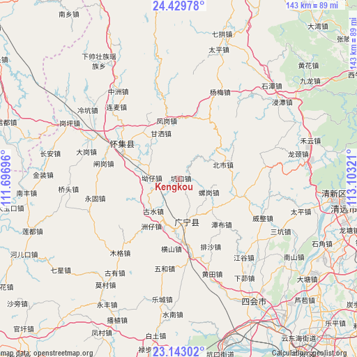
Kengkou GPS coordinates[2]
23° 47' 16.764" North, 112° 24' 0.288" East
| Map corner | latitude | longitude |
|---|---|---|
| Upper-left | 24.42978°, | 111.69696° |
| Center: | 23.78799°, | 112.40008° |
| Lower-right: | 23.14302°, | 113.10321° |
| Map W x H: | 143.1×143.1 km | = 88.9×88.9mi |
| max Lat: | 53.31946° ⇑91% North |
| Kengkou: | 23.78799° |
| min Lat: | ⇓9% South 18.22056° |
| min Long | Kengkou | max Long |
| 75.07348° | 112.40008° | 134.28917° |
| W 39.4%⇐ | ⇒60.6% E |
Elevation
Elevation of Kengkou is 136 m = 446 ft, and this is 348.8 m = 1144 ft below average elevation for this country.
| Max E: |
5622 m = 18445 ft | 54.2% |
| Avg. | 484.8 m = 1591 ft | |
| Kengkou | 136 m = 446 ft | |
Min E: |
-3 m = -10 ft | 45.8% |
See also: China elevation on elevation.city.
Geographical zone
Kengkou is located in North temperate zone (between Tropic of Cancer and the Arctic Circle). Distance of this Northern Tropic circle is 39.1 km =24.3 mi to South.| Distance of | km | miles | from Kengkou |
|---|---|---|---|
| North Pole | 7362.1 | 4574.6 | to North |
| Arctic Circle | 4756.2 | 2955.4 | to North |
| Tropic Cancer | 39.1 | 24.3 | to South |
| Equator | 2645 | 1643.5 | to South |


Nearby cities:
15 places around Kengkou: (largest is in red/bold)
• Aozai
9.7 km =6 mi,  273°
273°
• Beishi
18.3 km =11.4 mi,  71°
71°
• Chikeng
10.5 km =6.5 mi,  48°
48°
• Fenggang
22.5 km =14 mi,  346°
346°
• Gansa
21.7 km =13.5 mi,  336°
336°
• Gushui
15.1 km =9.4 mi,  221°
221°
• Hengshan
28.7 km =17.8 mi,  185°
185°
• Huaicheng
27.1 km =16.8 mi,  302°
302°
• Jiangtun
23.5 km =14.6 mi,  108°
108°
• Lianhe
26.6 km =16.5 mi,  103°
103°
• Luogang
12.9 km =8 mi,  120°
120°
• Nanjie
17.5 km =10.9 mi,  168°
168°
• Tanbu
24.5 km =15.2 mi,  138°
138°
• Wenlang
24.9 km =15.5 mi,  331°
331°
• Zhouzai
21.9 km =13.6 mi,  211°
211°
Sources, notices
• [Note1] Compared only with cities in China existing in our database
• [Src1] Map data: © OpenStreetMap contributors (CC-BY-SA)
• [Src2] Other city data from geonames.org with taken over terms of usage.
• [Src3] Geographical zone / Annual Mean Temperature by Robert A. Rohde @ Wikipedia
