Dongli geodata
Dongli (Guangdong) is a seat of a fourth-order administrative division; located in China in Asia/Urumqi (GMT+6) time zone. In our database, there are 1268 cities with bigger population. Compared to other cities in China, 98.5% of cities are located further ↑North; 69.7% of cities are located further →East and 87.7% of cities have higher elevation than Dongli. Note1


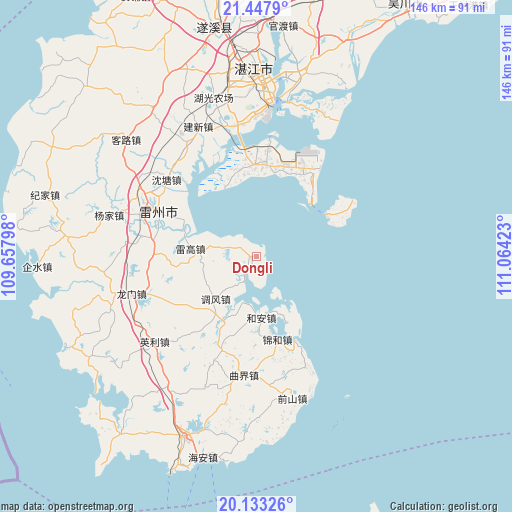
Dongli GPS coordinates[2]
20° 47' 31.236" North, 110° 21' 39.96" East
| Map corner | latitude | longitude |
|---|---|---|
| Upper-left | 21.4479°, | 109.65798° |
| Center: | 20.79201°, | 110.3611° |
| Lower-right: | 20.13326°, | 111.06423° |
| Map W x H: | 146.2×146.2 km | = 90.8×90.8mi |
| max Lat: | 53.31946° ⇑98.5% North |
| Dongli: | 20.79201° |
| min Lat: | ⇓1.5% South 18.22056° |
| min Long | Dongli | max Long |
| 75.07348° | 110.3611° | 134.28917° |
| W 30.3%⇐ | ⇒69.7% E |
Elevation
Elevation of Dongli is 12 m = 39 ft, and this is 472.8 m = 1551 ft below average elevation for this country.
| Max E: |
5622 m = 18445 ft | 87.7% |
| Avg. | 484.8 m = 1591 ft | |
| Dongli | 12 m = 39 ft | |
Min E: |
-3 m = -10 ft | 12.3% |
See also: China elevation on elevation.city.
Geographical zone
Dongli is located in North Torrid zone (between Equator and Tropic of Cancer). Distance of this Northern Tropic circle is 294.1 km =182.7 mi to North.| Distance of | km | miles | from Dongli |
|---|---|---|---|
| North Pole | 7695.2 | 4781.6 | to North |
| Arctic Circle | 5089.3 | 3162.3 | to North |
| Tropic Cancer | 294.1 | 182.7 | to North |
| Equator | 2311.9 | 1436.5 | to South |


Nearby cities:
15 places around Dongli: (largest is in red/bold)
• Baisha
30.3 km =18.8 mi,  291°
291°
• Dongjian
30.6 km =19 mi,  27°
27°
• Dongshan
27.2 km =16.9 mi,  6°
6°
• Fucheng
31.2 km =19.4 mi,  297°
297°
• He’an
18.1 km =11.2 mi,  177°
177°
• Jinhe
25.1 km =15.6 mi,  168°
168°
• Leicheng
31.9 km =19.8 mi, 295°
• Leigao
17.5 km =10.9 mi,  276°
276°
• Min’an
25 km =15.5 mi,  350°
350°
• Nanxing
27.8 km =17.3 mi,  272°
272°
• Qujie
34.3 km =21.3 mi,  186°
186°
• Shentang
34 km =21.1 mi,  312°
312°
• Songzhu
32.3 km =20.1 mi, 282°
• Tiaofeng
16.3 km =10.1 mi,  224°
224°
• Xinliao
21.8 km =13.5 mi,  150°
150°
Sources, notices
• [Note1] Compared only with cities in China existing in our database
• [Src1] Map data: © OpenStreetMap contributors (CC-BY-SA)
• [Src2] Other city data from geonames.org with taken over terms of usage.
• [Src3] Geographical zone / Annual Mean Temperature by Robert A. Rohde @ Wikipedia
