Ma’an geodata
Ma’an (Guangdong) is a seat of a fourth-order administrative division; located in China in Asia/Shanghai (GMT+8) time zone. In our database, there are 1268 cities with bigger population. Compared to other cities in China, 94.2% of cities are located further ↑North; 51.6% of cities are located further ←West and 85.5% of cities have higher elevation than Ma’an. Note1


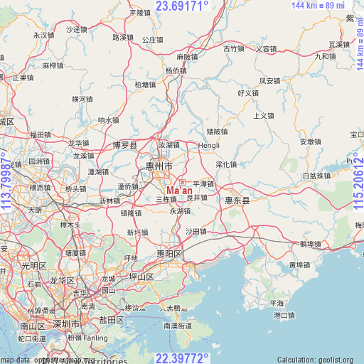
Ma’an GPS coordinates[2]
23° 2' 46.572" North, 114° 30' 10.764" East
| Map corner | latitude | longitude |
|---|---|---|
| Upper-left | 23.69171°, | 113.79987° |
| Center: | 23.04627°, | 114.50299° |
| Lower-right: | 22.39772°, | 115.20612° |
| Map W x H: | 143.9×143.9 km | = 89.4×89.4mi |
| max Lat: | 53.31946° ⇑94.2% North |
| Ma’an: | 23.04627° |
| min Lat: | ⇓5.8% South 18.22056° |
| min Long | Ma’an | max Long |
| 75.07348° | 114.50299° | 134.28917° |
| W 51.6%⇐ | ⇒48.4% E |
Elevation
Elevation of Ma’an is 15 m = 49 ft, and this is 469.8 m = 1541 ft below average elevation for this country.
| Max E: |
5622 m = 18445 ft | 85.5% |
| Avg. | 484.8 m = 1591 ft | |
| Ma’an | 15 m = 49 ft | |
Min E: |
-3 m = -10 ft | 14.5% |
See also: China elevation on elevation.city.
Geographical zone
Ma’an is located in North Torrid zone (between Equator and Tropic of Cancer). Distance of this Northern Tropic circle is 43.4 km =27 mi to North.| Distance of | km | miles | from Ma’an |
|---|---|---|---|
| North Pole | 7444.6 | 4625.9 | to North |
| Arctic Circle | 4838.7 | 3006.6 | to North |
| Tropic Cancer | 43.4 | 27 | to North |
| Equator | 2562.5 | 1592.3 | to South |


Nearby cities:
15 places around Ma’an: (largest is in red/bold)
• Baihua
18 km =11.2 mi,  124°
124°
• Henan’an
9.1 km =5.7 mi,  288°
288°
• Hengli
18.3 km =11.4 mi,  40°
40°
• Huihuan
14 km =8.7 mi,  263°
263°
• Huizhou
11.5 km =7.1 mi,  308°
308°
• Lianghua
19.6 km =12.2 mi,  66°
66°
• Liangjing
8.1 km =5 mi,  126°
126°
• Longfeng
12.8 km =8 mi,  283°
283°
• Pingtan
8.2 km =5.1 mi,  87°
87°
• Ruhu
16.2 km =10.1 mi,  340°
340°
• Sandong
7.9 km =4.9 mi,  225°
225°
• Shatian
19.5 km =12.1 mi,  165°
165°
• Shuikou
12.1 km =7.5 mi,  8°
8°
• Tongqiao
17.2 km =10.7 mi, 259°
• Yonghu
10.8 km =6.7 mi,  188°
188°
Sources, notices
• [Note1] Compared only with cities in China existing in our database
• [Src1] Map data: © OpenStreetMap contributors (CC-BY-SA)
• [Src2] Other city data from geonames.org with taken over terms of usage.
• [Src3] Geographical zone / Annual Mean Temperature by Robert A. Rohde @ Wikipedia
