Huizhou geodata
Huizhou (Guangdong) is a seat of a second-order administrative division; located in China in Asia/Shanghai (GMT+8) time zone. With population of 289,201 people, there are 183 cities with bigger population in this country. Compared to other cities in China, 93.9% of cities are located further ↑North; 51.1% of cities are located further ←West and 80.8% of cities have higher elevation than Huizhou. Note1


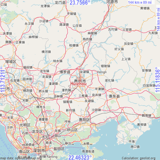
Huizhou GPS coordinates[2]
23° 6' 41.292" North, 114° 24' 54.828" East
| Map corner | latitude | longitude |
|---|---|---|
| Upper-left | 23.7566°, | 113.71211° |
| Center: | 23.11147°, | 114.41523° |
| Lower-right: | 22.46323°, | 115.11836° |
| Map W x H: | 143.8×143.8 km | = 89.4×89.4mi |
| max Lat: | 53.31946° ⇑93.9% North |
| Huizhou: | 23.11147° |
| min Lat: | ⇓6.1% South 18.22056° |
| min Long | Huizhou | max Long |
| 75.07348° | 114.41523° | 134.28917° |
| W 51.1%⇐ | ⇒48.9% E |
Elevation
Elevation of Huizhou is 25 m = 82 ft, and this is 459.8 m = 1509 ft below average elevation for this country.
| Max E: |
5622 m = 18445 ft | 80.8% |
| Avg. | 484.8 m = 1591 ft | |
| Huizhou | 25 m = 82 ft | |
Min E: |
-3 m = -10 ft | 19.2% |
See also: Huizhou elevation on elevation.city.
Geographical zone
Huizhou is located in North Torrid zone (between Equator and Tropic of Cancer). Distance of this Northern Tropic circle is 36.2 km =22.5 mi to North.| Distance of | km | miles | from Huizhou |
|---|---|---|---|
| North Pole | 7437.3 | 4621.3 | to North |
| Arctic Circle | 4831.4 | 3002.1 | to North |
| Tropic Cancer | 36.2 | 22.5 | to North |
| Equator | 2569.8 | 1596.8 | to South |


Nearby cities:
15 places around Huizhou: (largest is in red/bold)
• Chenjiang
14.5 km =9 mi,  230°
230°
• Henan’an
4.3 km =2.7 mi,  175°
175°
• Hengli
22 km =13.7 mi,  72°
72°
• Huihuan
10.1 km =6.3 mi,  209°
209°
• Liangjing
19.7 km =12.2 mi,  127°
127°
• Longfeng
5.5 km =3.4 mi,  218°
218°
• Luoyang
15.6 km =9.7 mi,  291°
291°
• Ma’an
11.5 km =7.1 mi, 128°
• Pingtan
18.5 km =11.5 mi,  111°
111°
• Ruhu
8.7 km =5.4 mi,  23°
23°
• Sandong
13.3 km =8.3 mi,  165°
165°
• Shuikou
11.8 km =7.3 mi, 66°
• Tongqiao
13 km =8.1 mi, 217°
• Xiaojinkou
10.3 km =6.4 mi,  346°
346°
• Yonghu
19.4 km =12.1 mi,  157°
157°
Sources, notices
• [Note1] Compared only with cities in China existing in our database
• [Src1] Map data: © OpenStreetMap contributors (CC-BY-SA)
• [Src2] Other city data from geonames.org with taken over terms of usage.
• [Src3] Geographical zone / Annual Mean Temperature by Robert A. Rohde @ Wikipedia
