Liangjing geodata
Liangjing (Guangdong) is a seat of a fourth-order administrative division; located in China in Asia/Shanghai (GMT+8) time zone. In our database, there are 1268 cities with bigger population. Compared to other cities in China, 94.5% of cities are located further ↑North; 51.9% of cities are located further ←West and 78.8% of cities have higher elevation than Liangjing. Note1


Liangjing GPS coordinates[2]
23° 0' 11.7" North, 114° 34' 1.704" East
| Map corner | latitude | longitude |
|---|---|---|
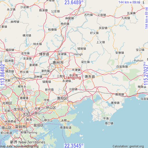
| Upper-left | 23.6489°, | 113.86402° |
| Center: | 23.00325°, | 114.56714° |
| Lower-right: | 22.3545°, | 115.27027° |
| Map W x H: | 143.9×143.9 km | = 89.4×89.4mi |
| max Lat: | 53.31946° ⇑94.5% North |
| Liangjing: | 23.00325° |
| min Lat: | ⇓5.5% South 18.22056° |
| min Long | Liangjing | max Long |
| 75.07348° | 114.56714° | 134.28917° |
| W 51.9%⇐ | ⇒48.1% E |
Elevation
Elevation of Liangjing is 29 m = 95 ft, and this is 455.8 m = 1495 ft below average elevation for this country.
| Max E: |
5622 m = 18445 ft | 78.8% |
| Avg. | 484.8 m = 1591 ft | |
| Liangjing | 29 m = 95 ft | |
Min E: |
-3 m = -10 ft | 21.2% |
See also: China elevation on elevation.city.
Geographical zone
Liangjing is located in North Torrid zone (between Equator and Tropic of Cancer). Distance of this Northern Tropic circle is 48.2 km =30 mi to North.| Distance of | km | miles | from Liangjing |
|---|---|---|---|
| North Pole | 7449.3 | 4628.8 | to North |
| Arctic Circle | 4843.5 | 3009.6 | to North |
| Tropic Cancer | 48.2 | 30 | to North |
| Equator | 2557.7 | 1589.3 | to South |


Nearby cities:
15 places around Liangjing: (largest is in red/bold)
• Baihua
9.9 km =6.2 mi,  122°
122°
• Daling
13.2 km =8.2 mi,  83°
83°
• Henan’an
17.1 km =10.6 mi,  296°
296°
• Hengli
19.5 km =12.1 mi,  16°
16°
• Huihuan
20.8 km =12.9 mi,  279°
279°
• Huizhou
19.7 km =12.2 mi,  307°
307°
• Lianghua
17 km =10.6 mi,  41°
41°
• Longfeng
20.5 km =12.7 mi,  292°
292°
• Ma’an
8.1 km =5 mi, 306°
• Pingshan
15 km =9.3 mi,  94°
94°
• Pingtan
5.5 km =3.4 mi, 17°
• Sandong
12.2 km =7.6 mi,  266°
266°
• Shatian
14.1 km =8.8 mi,  186°
186°
• Shuikou
17.4 km =10.8 mi,  344°
344°
• Yonghu
10.1 km =6.3 mi,  234°
234°
Sources, notices
• [Note1] Compared only with cities in China existing in our database
• [Src1] Map data: © OpenStreetMap contributors (CC-BY-SA)
• [Src2] Other city data from geonames.org with taken over terms of usage.
• [Src3] Geographical zone / Annual Mean Temperature by Robert A. Rohde @ Wikipedia
