Lianghua geodata
Lianghua (Guangdong) is a seat of a fourth-order administrative division; located in China in Asia/Shanghai (GMT+8) time zone. In our database, there are 1268 cities with bigger population. Compared to other cities in China, 93.9% of cities are located further ↑North; 52.5% of cities are located further ←West and 78.8% of cities have higher elevation than Lianghua. Note1


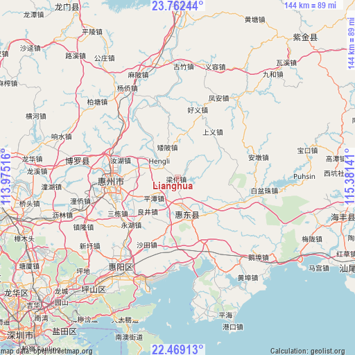
Lianghua GPS coordinates[2]
23° 7' 2.424" North, 114° 40' 41.808" East
| Map corner | latitude | longitude |
|---|---|---|
| Upper-left | 23.76244°, | 113.97516° |
| Center: | 23.11734°, | 114.67828° |
| Lower-right: | 22.46913°, | 115.38141° |
| Map W x H: | 143.8×143.8 km | = 89.4×89.4mi |
| max Lat: | 53.31946° ⇑93.9% North |
| Lianghua: | 23.11734° |
| min Lat: | ⇓6.1% South 18.22056° |
| min Long | Lianghua | max Long |
| 75.07348° | 114.67828° | 134.28917° |
| W 52.5%⇐ | ⇒47.5% E |
Elevation
Elevation of Lianghua is 29 m = 95 ft, and this is 455.8 m = 1495 ft below average elevation for this country.
| Max E: |
5622 m = 18445 ft | 78.8% |
| Avg. | 484.8 m = 1591 ft | |
| Lianghua | 29 m = 95 ft | |
Min E: |
-3 m = -10 ft | 21.2% |
See also: China elevation on elevation.city.
Geographical zone
Lianghua is located in North Torrid zone (between Equator and Tropic of Cancer). Distance of this Northern Tropic circle is 35.5 km =22.1 mi to North.| Distance of | km | miles | from Lianghua |
|---|---|---|---|
| North Pole | 7436.7 | 4620.9 | to North |
| Arctic Circle | 4830.8 | 3001.7 | to North |
| Tropic Cancer | 35.5 | 22.1 | to North |
| Equator | 2570.4 | 1597.2 | to South |


Nearby cities:
15 places around Lianghua: (largest is in red/bold)
• Aipi
13 km =8.1 mi,  341°
341°
• Baihua
18.3 km =11.4 mi,  189°
189°
• Dalan
18.7 km =11.6 mi,  11°
11°
• Daling
11.4 km =7.1 mi,  171°
171°
• Hengli
8.5 km =5.3 mi,  315°
315°
• Liangjing
17 km =10.6 mi,  221°
221°
• Ma’an
19.6 km =12.2 mi,  246°
246°
• Pingshan
14.2 km =8.8 mi, 165°
• Pingtan
12.3 km =7.6 mi,  232°
232°
• Ruhu
24.5 km =15.2 mi,  287°
287°
• Shangyi
23.4 km =14.5 mi,  39°
39°
• Shuikou
16.6 km =10.3 mi,  284°
284°
• Songkeng
25.1 km =15.6 mi,  73°
73°
• Yonghu
26.9 km =16.7 mi, 226°
• Zengguang
22.7 km =14.1 mi,  119°
119°
Sources, notices
• [Note1] Compared only with cities in China existing in our database
• [Src1] Map data: © OpenStreetMap contributors (CC-BY-SA)
• [Src2] Other city data from geonames.org with taken over terms of usage.
• [Src3] Geographical zone / Annual Mean Temperature by Robert A. Rohde @ Wikipedia
