Xiache geodata
Xiache (Guangdong) is a seat of a fourth-order administrative division; located in China in Asia/Shanghai (GMT+8) time zone. In our database, there are 1268 cities with bigger population. Compared to other cities in China, 87.9% of cities are located further ↑North; 54.9% of cities are located further ←West and 56.4% of cities have lower elevation than Xiache. Note1


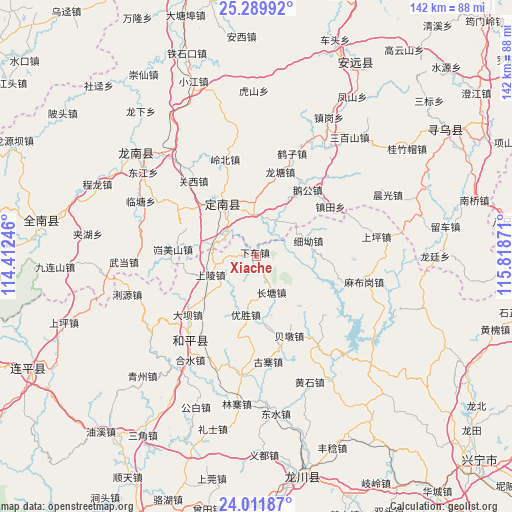
Xiache GPS coordinates[2]
24° 39' 9.108" North, 115° 6' 56.088" East
| Map corner | latitude | longitude |
|---|---|---|
| Upper-left | 25.28992°, | 114.41246° |
| Center: | 24.65253°, | 115.11558° |
| Lower-right: | 24.01187°, | 115.81871° |
| Map W x H: | 142.1×142.1 km | = 88.3×88.3mi |
| max Lat: | 53.31946° ⇑87.9% North |
| Xiache: | 24.65253° |
| min Lat: | ⇓12.1% South 18.22056° |
| min Long | Xiache | max Long |
| 75.07348° | 115.11558° | 134.28917° |
| W 54.9%⇐ | ⇒45.1% E |
Elevation
Elevation of Xiache is 220 m = 722 ft, and this is 264.8 m = 869 ft below average elevation for this country.
| Max E: |
5622 m = 18445 ft | 43.6% |
| Avg. | 484.8 m = 1591 ft | |
| Xiache | 220 m = 722 ft | |
Min E: |
-3 m = -10 ft | 56.4% |
See also: China elevation on elevation.city.
Geographical zone
Xiache is located in North temperate zone (between Tropic of Cancer and the Arctic Circle). Distance of this Northern Tropic circle is 135.2 km =84 mi to South.| Distance of | km | miles | from Xiache |
|---|---|---|---|
| North Pole | 7266 | 4514.9 | to North |
| Arctic Circle | 4660.1 | 2895.7 | to North |
| Tropic Cancer | 135.2 | 84 | to South |
| Equator | 2741.1 | 1703.2 | to South |


Nearby cities:
15 places around Xiache: (largest is in red/bold)
• Beidun
23.9 km =14.9 mi,  156°
156°
• Beiling
23.4 km =14.5 mi,  105°
105°
• Changtang
11 km =6.8 mi, 163°
• Daba
24.3 km =15.1 mi,  228°
228°
• Guanxi
27.3 km =17 mi,  320°
320°
• Guzhai
29.3 km =18.2 mi,  173°
173°
• Kuimeishan
23.1 km =14.4 mi,  274°
274°
• Laocheng
13.4 km =8.3 mi,  287°
287°
• Lishi
18.8 km =11.7 mi,  333°
333°
• Shangling
13.9 km =8.6 mi,  245°
245°
• Wenlong
25.3 km =15.7 mi,  300°
300°
• Xi’ao
15.4 km =9.6 mi,  73°
73°
• Yangming
28.7 km =17.8 mi,  219°
219°
• Yousheng
16.2 km =10.1 mi,  190°
190°
• Zhentian
24.9 km =15.5 mi,  55°
55°
Sources, notices
• [Note1] Compared only with cities in China existing in our database
• [Src1] Map data: © OpenStreetMap contributors (CC-BY-SA)
• [Src2] Other city data from geonames.org with taken over terms of usage.
• [Src3] Geographical zone / Annual Mean Temperature by Robert A. Rohde @ Wikipedia
