Fenglin geodata
Fenglin (Zhejiang) is a seat of a fourth-order administrative division; located in China in Asia/Shanghai (GMT+8) time zone. In our database, there are 1268 cities with bigger population. Compared to other cities in China, 69.5% of cities are located further ↑North; 73.3% of cities are located further ←West and 50.6% of cities have higher elevation than Fenglin. Note1


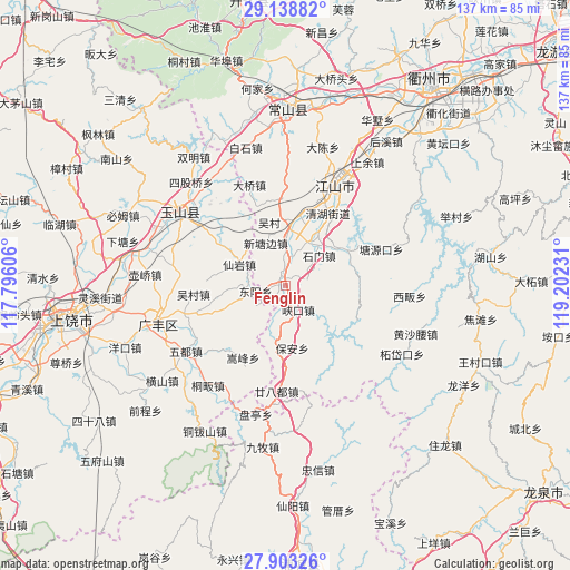
Fenglin GPS coordinates[2]
28° 31' 22.26" North, 118° 29' 57.048" East
| Map corner | latitude | longitude |
|---|---|---|
| Upper-left | 29.13882°, | 117.79606° |
| Center: | 28.52285°, | 118.49918° |
| Lower-right: | 27.90326°, | 119.20231° |
| Map W x H: | 137.4×137.4 km | = 85.4×85.4mi |
| max Lat: | 53.31946° ⇑69.5% North |
| Fenglin: | 28.52285° |
| min Lat: | ⇓30.5% South 18.22056° |
| min Long | Fenglin | max Long |
| 75.07348° | 118.49918° | 134.28917° |
| W 73.3%⇐ | ⇒26.7% E |
Elevation
Elevation of Fenglin is 159 m = 522 ft, and this is 325.8 m = 1069 ft below average elevation for this country.
| Max E: |
5622 m = 18445 ft | 50.6% |
| Avg. | 484.8 m = 1591 ft | |
| Fenglin | 159 m = 522 ft | |
Min E: |
-3 m = -10 ft | 49.4% |
See also: China elevation on elevation.city.
Geographical zone
Fenglin is located in North temperate zone (between Tropic of Cancer and the Arctic Circle). Distance of this Northern Tropic circle is 565.5 km =351.4 mi to South.| Distance of | km | miles | from Fenglin |
|---|---|---|---|
| North Pole | 6835.6 | 4247.4 | to North |
| Arctic Circle | 4229.7 | 2628.2 | to North |
| Tropic Cancer | 565.5 | 351.4 | to South |
| Equator | 3171.4 | 1970.6 | to South |


Nearby cities:
15 places around Fenglin: (largest is in red/bold)
• Guancun
9 km =5.6 mi,  234°
234°
• Hecun
16.6 km =10.3 mi,  9°
9°
• Huacun
21.3 km =13.2 mi,  289°
289°
• Maocun
19.5 km =12.1 mi,  222°
222°
• Maofan
2.6 km =1.6 mi,  330°
330°
• Quanbo
22.6 km =14 mi, 225°
• Shehou
13.7 km =8.5 mi,  249°
249°
• Songfeng
20.8 km =12.9 mi,  209°
209°
• Tanshi
21.4 km =13.3 mi,  358°
358°
• Wucun
15.9 km =9.9 mi,  343°
343°
• Wucun
21.9 km =13.6 mi,  263°
263°
• Xianyan
11.7 km =7.3 mi,  298°
298°
• Xiazhen
16.6 km =10.3 mi, 325°
• Xintangbian
11.9 km =7.4 mi, 337°
• Yutou
11 km =6.8 mi,  3°
3°
Sources, notices
• [Note1] Compared only with cities in China existing in our database
• [Src1] Map data: © OpenStreetMap contributors (CC-BY-SA)
• [Src2] Other city data from geonames.org with taken over terms of usage.
• [Src3] Geographical zone / Annual Mean Temperature by Robert A. Rohde @ Wikipedia
