Baoyang geodata
Baoyang (Zhejiang) is a seat of a fourth-order administrative division; located in China in Asia/Shanghai (GMT+8) time zone. In our database, there are 1268 cities with bigger population. Compared to other cities in China, 75.9% of cities are located further ↑North; 81.6% of cities are located further ←West and 69.1% of cities have lower elevation than Baoyang. Note1


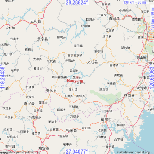
Baoyang GPS coordinates[2]
27° 39' 55.008" North, 119° 56' 51" East
| Map corner | latitude | longitude |
|---|---|---|
| Upper-left | 28.28624°, | 119.24438° |
| Center: | 27.66528°, | 119.9475° |
| Lower-right: | 27.04077°, | 120.65063° |
| Map W x H: | 138.5×138.5 km | = 86.1×86.1mi |
| max Lat: | 53.31946° ⇑75.9% North |
| Baoyang: | 27.66528° |
| min Lat: | ⇓24.1% South 18.22056° |
| min Long | Baoyang | max Long |
| 75.07348° | 119.9475° | 134.28917° |
| W 81.6%⇐ | ⇒18.4% E |
Elevation
Elevation of Baoyang is 394 m = 1293 ft, and this is 90.8 m = 298 ft below average elevation for this country.
| Max E: |
5622 m = 18445 ft | 30.9% |
| Avg. | 484.8 m = 1591 ft | |
| Baoyang | 394 m = 1293 ft | |
Min E: |
-3 m = -10 ft | 69.1% |
See also: China elevation on elevation.city.
Geographical zone
Baoyang is located in North temperate zone (between Tropic of Cancer and the Arctic Circle). Distance of this Northern Tropic circle is 470.2 km =292.2 mi to South.| Distance of | km | miles | from Baoyang |
|---|---|---|---|
| North Pole | 6931 | 4306.7 | to North |
| Arctic Circle | 4325.1 | 2687.5 | to North |
| Tropic Cancer | 470.2 | 292.2 | to South |
| Equator | 3076.1 | 1911.4 | to South |


Nearby cities:
15 places around Baoyang: (largest is in red/bold)
• Baizhang
9.6 km =6 mi,  263°
263°
• Fengmen
9.4 km =5.8 mi,  292°
292°
• Fengyang
17 km =10.6 mi,  169°
169°
• Fu’ao
15.9 km =9.9 mi,  6°
6°
• Huangqiao
19.5 km =12.1 mi,  310°
310°
• Lianyun
5.9 km =3.7 mi,  142°
142°
• Linghou
16.5 km =10.3 mi,  338°
338°
• Siqian
16 km =9.9 mi,  271°
271°
• Wengshan
11 km =6.8 mi, 166°
• Xiahong
18.4 km =11.4 mi,  204°
204°
• Xiaocun
11.6 km =7.2 mi, 199°
• Xinpu
4.4 km =2.7 mi, 200°
• Yunhu
6.9 km =4.3 mi, 336°
• Zhishan
6.3 km =3.9 mi,  333°
333°
• Zhuli
18.3 km =11.4 mi, 285°
Sources, notices
• [Note1] Compared only with cities in China existing in our database
• [Src1] Map data: © OpenStreetMap contributors (CC-BY-SA)
• [Src2] Other city data from geonames.org with taken over terms of usage.
• [Src3] Geographical zone / Annual Mean Temperature by Robert A. Rohde @ Wikipedia
