Xinpu geodata
Xinpu (Zhejiang) is a seat of a fourth-order administrative division; located in China in Asia/Shanghai (GMT+8) time zone. In our database, there are 1268 cities with bigger population. Compared to other cities in China, 76.1% of cities are located further ↑North; 81.5% of cities are located further ←West and 61.6% of cities have lower elevation than Xinpu. Note1


Xinpu GPS coordinates[2]
27° 37' 42.348" North, 119° 55' 54.192" East
| Map corner | latitude | longitude |
|---|---|---|
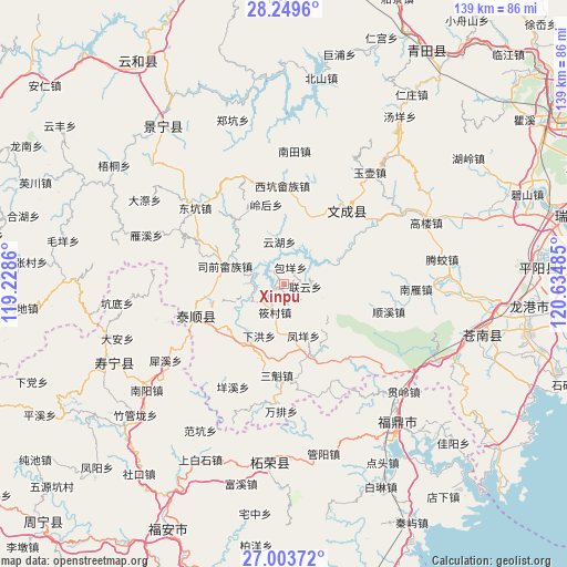
| Upper-left | 28.2496°, | 119.2286° |
| Center: | 27.62843°, | 119.93172° |
| Lower-right: | 27.00372°, | 120.63485° |
| Map W x H: | 138.5×138.5 km | = 86.1×86.1mi |
| max Lat: | 53.31946° ⇑76.1% North |
| Xinpu: | 27.62843° |
| min Lat: | ⇓23.9% South 18.22056° |
| min Long | Xinpu | max Long |
| 75.07348° | 119.93172° | 134.28917° |
| W 81.5%⇐ | ⇒18.5% E |
Elevation
Elevation of Xinpu is 278 m = 912 ft, and this is 206.8 m = 678 ft below average elevation for this country.
| Max E: |
5622 m = 18445 ft | 38.4% |
| Avg. | 484.8 m = 1591 ft | |
| Xinpu | 278 m = 912 ft | |
Min E: |
-3 m = -10 ft | 61.6% |
See also: China elevation on elevation.city.
Geographical zone
Xinpu is located in North temperate zone (between Tropic of Cancer and the Arctic Circle). Distance of this Northern Tropic circle is 466.1 km =289.6 mi to South.| Distance of | km | miles | from Xinpu |
|---|---|---|---|
| North Pole | 6935.1 | 4309.3 | to North |
| Arctic Circle | 4329.2 | 2690 | to North |
| Tropic Cancer | 466.1 | 289.6 | to South |
| Equator | 3072 | 1908.9 | to South |


Nearby cities:
15 places around Xinpu: (largest is in red/bold)
• Baizhang
8.5 km =5.3 mi,  290°
290°
• Baoyang
4.4 km =2.7 mi,  20°
20°
• Da’an
20 km =12.4 mi,  194°
194°
• Fengmen
10.6 km =6.6 mi,  317°
317°
• Fengyang
13.4 km =8.3 mi,  159°
159°
• Lianyun
5.2 km =3.2 mi,  96°
96°
• Linghou
19.9 km =12.4 mi,  347°
347°
• Siqian
15.1 km =9.4 mi, 287°
• Wengshan
7.7 km =4.8 mi,  148°
148°
• Xiahong
14 km =8.7 mi,  206°
206°
• Xianren
18.1 km =11.2 mi,  256°
256°
• Xiaocun
7.2 km =4.5 mi,  198°
198°
• Yunhu
10.4 km =6.5 mi, 353°
• Zhishan
9.9 km =6.2 mi, 352°
• Zhuli
18.4 km =11.4 mi,  298°
298°
Sources, notices
• [Note1] Compared only with cities in China existing in our database
• [Src1] Map data: © OpenStreetMap contributors (CC-BY-SA)
• [Src2] Other city data from geonames.org with taken over terms of usage.
• [Src3] Geographical zone / Annual Mean Temperature by Robert A. Rohde @ Wikipedia
