Dengyun geodata
Dengyun (Guangdong) is a seat of a fourth-order administrative division; located in China in Asia/Shanghai (GMT+8) time zone. In our database, there are 1268 cities with bigger population. Compared to other cities in China, 90.2% of cities are located further ↑North; 56.4% of cities are located further ←West and 57.7% of cities have lower elevation than Dengyun. Note1


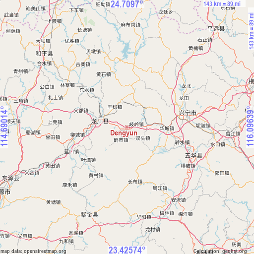
Dengyun GPS coordinates[2]
24° 4' 9.588" North, 115° 23' 35.736" East
| Map corner | latitude | longitude |
|---|---|---|
| Upper-left | 24.7097°, | 114.69014° |
| Center: | 24.06933°, | 115.39326° |
| Lower-right: | 23.42574°, | 116.09639° |
| Map W x H: | 142.8×142.8 km | = 88.7×88.7mi |
| max Lat: | 53.31946° ⇑90.2% North |
| Dengyun: | 24.06933° |
| min Lat: | ⇓9.8% South 18.22056° |
| min Long | Dengyun | max Long |
| 75.07348° | 115.39326° | 134.28917° |
| W 56.4%⇐ | ⇒43.6% E |
Elevation
Elevation of Dengyun is 233 m = 764 ft, and this is 251.8 m = 826 ft below average elevation for this country.
| Max E: |
5622 m = 18445 ft | 42.3% |
| Avg. | 484.8 m = 1591 ft | |
| Dengyun | 233 m = 764 ft | |
Min E: |
-3 m = -10 ft | 57.7% |
See also: China elevation on elevation.city.
Geographical zone
Dengyun is located in North temperate zone (between Tropic of Cancer and the Arctic Circle). Distance of this Northern Tropic circle is 70.3 km =43.7 mi to South.| Distance of | km | miles | from Dengyun |
|---|---|---|---|
| North Pole | 7330.8 | 4555.1 | to North |
| Arctic Circle | 4724.9 | 2935.9 | to North |
| Tropic Cancer | 70.3 | 43.7 | to South |
| Equator | 2676.3 | 1663 | to South |


Nearby cities:
15 places around Dengyun: (largest is in red/bold)
• Fengren
13.4 km =8.3 mi,  329°
329°
• Fucheng
16.8 km =10.4 mi,  281°
281°
• Guqian
13 km =8.1 mi,  14°
14°
• Heshi
7.6 km =4.7 mi,  207°
207°
• Huangbu
13.8 km =8.6 mi,  223°
223°
• Laolong
15.1 km =9.4 mi, 284°
• Qiling
6 km =3.7 mi,  66°
66°
• Shizikeng
2.2 km =1.4 mi,  28°
28°
• Shuangtou
10.5 km =6.5 mi,  119°
119°
• Tanxia
20 km =12.4 mi,  133°
133°
• Tiechang
14.5 km =9 mi,  43°
43°
• Tongqu
2.9 km =1.8 mi, 218°
• Tuocheng
20.8 km =12.9 mi,  267°
267°
• Xinqiao
20 km =12.4 mi,  62°
62°
• Zishi
15.9 km =9.9 mi,  195°
195°
Sources, notices
• [Note1] Compared only with cities in China existing in our database
• [Src1] Map data: © OpenStreetMap contributors (CC-BY-SA)
• [Src2] Other city data from geonames.org with taken over terms of usage.
• [Src3] Geographical zone / Annual Mean Temperature by Robert A. Rohde @ Wikipedia
