Songkeng geodata
Songkeng (Guangdong) is a seat of a fourth-order administrative division; located in China in Asia/Shanghai (GMT+8) time zone. In our database, there are 1268 cities with bigger population. Compared to other cities in China, 93.6% of cities are located further ↑North; 53.7% of cities are located further ←West and 54.6% of cities have lower elevation than Songkeng. Note1


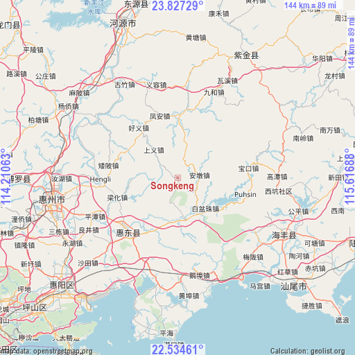
Songkeng GPS coordinates[2]
23° 10' 57.036" North, 114° 54' 49.5" East
| Map corner | latitude | longitude |
|---|---|---|
| Upper-left | 23.82729°, | 114.21063° |
| Center: | 23.18251°, | 114.91375° |
| Lower-right: | 22.53461°, | 115.61688° |
| Map W x H: | 143.7×143.7 km | = 89.3×89.3mi |
| max Lat: | 53.31946° ⇑93.6% North |
| Songkeng: | 23.18251° |
| min Lat: | ⇓6.4% South 18.22056° |
| min Long | Songkeng | max Long |
| 75.07348° | 114.91375° | 134.28917° |
| W 53.7%⇐ | ⇒46.3% E |
Elevation
Elevation of Songkeng is 203 m = 666 ft, and this is 281.8 m = 925 ft below average elevation for this country.
| Max E: |
5622 m = 18445 ft | 45.4% |
| Avg. | 484.8 m = 1591 ft | |
| Songkeng | 203 m = 666 ft | |
Min E: |
-3 m = -10 ft | 54.6% |
See also: China elevation on elevation.city.
Geographical zone
Songkeng is located in North Torrid zone (between Equator and Tropic of Cancer). Distance of this Northern Tropic circle is 28.3 km =17.6 mi to North.| Distance of | km | miles | from Songkeng |
|---|---|---|---|
| North Pole | 7429.4 | 4616.4 | to North |
| Arctic Circle | 4823.5 | 2997.2 | to North |
| Tropic Cancer | 28.3 | 17.6 | to North |
| Equator | 2577.7 | 1601.7 | to South |


Nearby cities:
15 places around Songkeng: (largest is in red/bold)
• Aipi
28.6 km =17.8 mi,  280°
280°
• Andun
9.3 km =5.8 mi,  89°
89°
• Baipenzhu
16.6 km =10.3 mi,  136°
136°
• Baokou
30.1 km =18.7 mi,  83°
83°
• Dalan
23.1 km =14.4 mi,  298°
298°
• Daling
29 km =18 mi,  230°
230°
• Duozhu
17.3 km =10.7 mi,  168°
168°
• Feng’an
26.4 km =16.4 mi,  344°
344°
• Haoyi
26.5 km =16.5 mi,  322°
322°
• Lantang
25.8 km =16 mi,  4°
4°
• Lianghua
25.1 km =15.6 mi,  253°
253°
• Pingshan
29.4 km =18.3 mi,  224°
224°
• Shangyi
14.1 km =8.8 mi, 319°
• Xin’an
29.2 km =18.1 mi,  103°
103°
• Zengguang
18.8 km =11.7 mi,  193°
193°
Sources, notices
• [Note1] Compared only with cities in China existing in our database
• [Src1] Map data: © OpenStreetMap contributors (CC-BY-SA)
• [Src2] Other city data from geonames.org with taken over terms of usage.
• [Src3] Geographical zone / Annual Mean Temperature by Robert A. Rohde @ Wikipedia
