Nanyanchuan geodata
Nanyanchuan (Hebei) is a seat of a fourth-order administrative division; located in China in Asia/Shanghai (GMT+8) time zone. In our database, there are 1268 cities with bigger population. Compared to other cities in China, 81.8% of cities are located further ↓South; 50% of cities are located further ←West and 52.8% of cities have lower elevation than Nanyanchuan. Note1


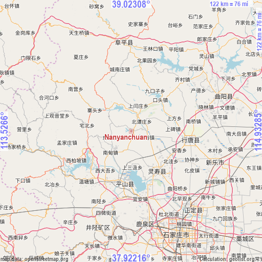
Nanyanchuan GPS coordinates[2]
38° 28' 28.992" North, 114° 13' 46.992" East
| Map corner | latitude | longitude |
|---|---|---|
| Upper-left | 39.02308°, | 113.5266° |
| Center: | 38.47472°, | 114.22972° |
| Lower-right: | 37.92216°, | 114.93285° |
| Map W x H: | 122.4×122.4 km | = 76.1×76.1mi |
| max Lat: | 53.31946° ⇑18.2% North |
| Nanyanchuan: | 38.47472° |
| min Lat: | ⇓81.8% South 18.22056° |
| min Long | Nanyanchuan | max Long |
| 75.07348° | 114.22972° | 134.28917° |
| W 50%⇐ | ⇒50% E |
Elevation
Elevation of Nanyanchuan is 187 m = 614 ft, and this is 297.8 m = 977 ft below average elevation for this country.
| Max E: |
5622 m = 18445 ft | 47.2% |
| Avg. | 484.8 m = 1591 ft | |
| Nanyanchuan | 187 m = 614 ft | |
Min E: |
-3 m = -10 ft | 52.8% |
See also: China elevation on elevation.city.
Geographical zone
Nanyanchuan is located in North temperate zone (between Tropic of Cancer and the Arctic Circle). Distance of this Northern Tropic circle is 1672.1 km =1039 mi to South.| Distance of | km | miles | from Nanyanchuan |
|---|---|---|---|
| North Pole | 5729.1 | 3559.9 | to North |
| Arctic Circle | 3123.2 | 1940.7 | to North |
| Tropic Cancer | 1672.1 | 1039 | to South |
| Equator | 4278 | 2658.2 | to South |


Nearby cities:
15 places around Nanyanchuan: (largest is in red/bold)
• Beitanzhuang
6.6 km =4.1 mi,  49°
49°
• Chatou
9.6 km =6 mi,  2°
2°
• Chengzhai
12.8 km =8 mi,  60°
60°
• Chenzhuang
15.5 km =9.6 mi,  312°
312°
• Ciyu
7.8 km =4.8 mi,  111°
111°
• Diying
18.8 km =11.7 mi,  103°
103°
• Dongwangpo
9.3 km =5.8 mi,  251°
251°
• Goutai
17.9 km =11.1 mi,  154°
154°
• Lianghe
16.8 km =10.4 mi,  201°
201°
• Nandian
13.3 km =8.3 mi,  222°
222°
• Nanzhai
18.3 km =11.4 mi,  129°
129°
• Qingtong
14.6 km =9.1 mi, 134°
• Shangsanji
16.9 km =10.5 mi,  180°
180°
• Shangyanzhuang
12.2 km =7.6 mi,  13°
13°
• Tashang
9.2 km =5.7 mi, 195°
Sources, notices
• [Note1] Compared only with cities in China existing in our database
• [Src1] Map data: © OpenStreetMap contributors (CC-BY-SA)
• [Src2] Other city data from geonames.org with taken over terms of usage.
• [Src3] Geographical zone / Annual Mean Temperature by Robert A. Rohde @ Wikipedia
