Dongwangpo geodata
Dongwangpo (Hebei) is a seat of a fourth-order administrative division; located in China in Asia/Shanghai (GMT+8) time zone. In our database, there are 1268 cities with bigger population. Compared to other cities in China, 81.7% of cities are located further ↓South; 50.5% of cities are located further →East and 50.8% of cities have lower elevation than Dongwangpo. Note1


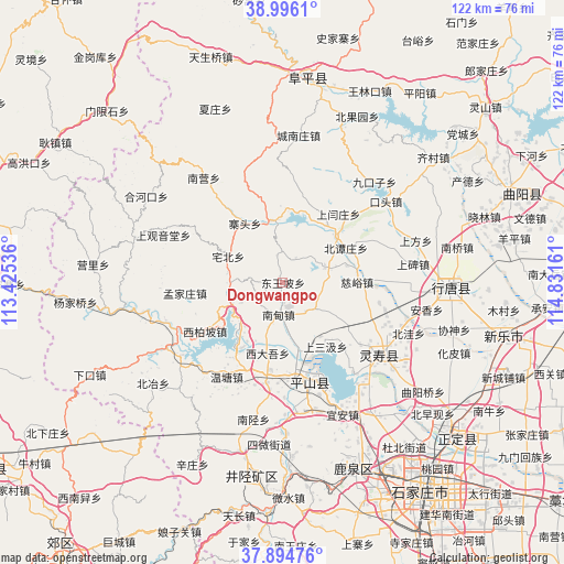
Dongwangpo GPS coordinates[2]
38° 26' 51.108" North, 114° 7' 42.528" East
| Map corner | latitude | longitude |
|---|---|---|
| Upper-left | 38.9961°, | 113.42536° |
| Center: | 38.44753°, | 114.12848° |
| Lower-right: | 37.89476°, | 114.83161° |
| Map W x H: | 122.5×122.5 km | = 76.1×76.1mi |
| max Lat: | 53.31946° ⇑18.3% North |
| Dongwangpo: | 38.44753° |
| min Lat: | ⇓81.7% South 18.22056° |
| min Long | Dongwangpo | max Long |
| 75.07348° | 114.12848° | 134.28917° |
| W 49.5%⇐ | ⇒50.5% E |
Elevation
Elevation of Dongwangpo is 172 m = 564 ft, and this is 312.8 m = 1026 ft below average elevation for this country.
| Max E: |
5622 m = 18445 ft | 49.2% |
| Avg. | 484.8 m = 1591 ft | |
| Dongwangpo | 172 m = 564 ft | |
Min E: |
-3 m = -10 ft | 50.8% |
See also: China elevation on elevation.city.
Geographical zone
Dongwangpo is located in North temperate zone (between Tropic of Cancer and the Arctic Circle). Distance of this Northern Tropic circle is 1669 km =1037.1 mi to South.| Distance of | km | miles | from Dongwangpo |
|---|---|---|---|
| North Pole | 5732.1 | 3561.8 | to North |
| Arctic Circle | 3126.2 | 1942.5 | to North |
| Tropic Cancer | 1669 | 1037.1 | to South |
| Equator | 4275 | 2656.4 | to South |


Nearby cities:
15 places around Dongwangpo: (largest is in red/bold)
• Beitanzhuang
15.7 km =9.8 mi,  62°
62°
• Chatou
15.7 km =9.8 mi,  36°
36°
• Chenzhuang
13.8 km =8.6 mi,  349°
349°
• Ciyu
16.1 km =10 mi,  89°
89°
• Gangnan
16.8 km =10.4 mi,  213°
213°
• Lianghe
12.8 km =8 mi,  168°
168°
• Nandian
6.8 km =4.2 mi,  180°
180°
• Nanyanchuan
9.3 km =5.8 mi,  71°
71°
• Qingtong
20.6 km =12.8 mi,  110°
110°
• Shangsanji
16.5 km =10.3 mi,  147°
147°
• Shangyanzhuang
18.9 km =11.7 mi, 38°
• Sujiazhuang
11.8 km =7.3 mi,  248°
248°
• Tashang
8.7 km =5.4 mi,  132°
132°
• Xidawu
15.9 km =9.9 mi,  190°
190°
• Zhaitou
15.8 km =9.8 mi,  326°
326°
Sources, notices
• [Note1] Compared only with cities in China existing in our database
• [Src1] Map data: © OpenStreetMap contributors (CC-BY-SA)
• [Src2] Other city data from geonames.org with taken over terms of usage.
• [Src3] Geographical zone / Annual Mean Temperature by Robert A. Rohde @ Wikipedia
