Beitanzhuang geodata
Beitanzhuang (Henan) is a seat of a fourth-order administrative division; located in China in Asia/Shanghai (GMT+8) time zone. In our database, there are 1268 cities with bigger population. Compared to other cities in China, 81.8% of cities are located further ↓South; 50.3% of cities are located further ←West and 50.7% of cities have lower elevation than Beitanzhuang. Note1


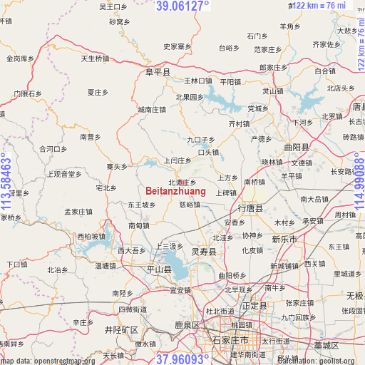
Beitanzhuang GPS coordinates[2]
38° 30' 47.52" North, 114° 17' 15.9" East
| Map corner | latitude | longitude |
|---|---|---|
| Upper-left | 39.06127°, | 113.58463° |
| Center: | 38.5132°, | 114.28775° |
| Lower-right: | 37.96093°, | 114.99088° |
| Map W x H: | 122.3×122.3 km | = 76×76mi |
| max Lat: | 53.31946° ⇑18.2% North |
| Beitanzhuang: | 38.5132° |
| min Lat: | ⇓81.8% South 18.22056° |
| min Long | Beitanzhuang | max Long |
| 75.07348° | 114.28775° | 134.28917° |
| W 50.3%⇐ | ⇒49.7% E |
Elevation
Elevation of Beitanzhuang is 171 m = 561 ft, and this is 313.8 m = 1030 ft below average elevation for this country.
| Max E: |
5622 m = 18445 ft | 49.3% |
| Avg. | 484.8 m = 1591 ft | |
| Beitanzhuang | 171 m = 561 ft | |
Min E: |
-3 m = -10 ft | 50.7% |
See also: China elevation on elevation.city.
Geographical zone
Beitanzhuang is located in North temperate zone (between Tropic of Cancer and the Arctic Circle). Distance of this Northern Tropic circle is 1676.3 km =1041.6 mi to South.| Distance of | km | miles | from Beitanzhuang |
|---|---|---|---|
| North Pole | 5724.8 | 3557.2 | to North |
| Arctic Circle | 3118.9 | 1938 | to North |
| Tropic Cancer | 1676.3 | 1041.6 | to South |
| Equator | 4282.3 | 2660.9 | to South |


Nearby cities:
15 places around Beitanzhuang: (largest is in red/bold)
• Chatou
7 km =4.3 mi,  319°
319°
• Chengzhai
6.4 km =4 mi,  72°
72°
• Chenzhuang
17.6 km =10.9 mi,  290°
290°
• Ciyu
7.5 km =4.7 mi,  162°
162°
• Diying
15.9 km =9.9 mi,  123°
123°
• Dongwangpo
15.7 km =9.8 mi,  242°
242°
• Jiukouzi
15.8 km =9.8 mi,  22°
22°
• Koutou
13.1 km =8.1 mi,  39°
39°
• Nanyanchuan
6.6 km =4.1 mi,  229°
229°
• Nanzhai
18.3 km =11.4 mi,  150°
150°
• Qingtong
15.5 km =9.6 mi, 159°
• Shangbei
15.1 km =9.4 mi,  102°
102°
• Shangfang
15 km =9.3 mi,  83°
83°
• Shangyanzhuang
7.8 km =4.8 mi,  344°
344°
• Tashang
15.1 km =9.4 mi,  209°
209°
Sources, notices
• [Note1] Compared only with cities in China existing in our database
• [Src1] Map data: © OpenStreetMap contributors (CC-BY-SA)
• [Src2] Other city data from geonames.org with taken over terms of usage.
• [Src3] Geographical zone / Annual Mean Temperature by Robert A. Rohde @ Wikipedia
