Qingtong geodata
Qingtong (Henan) is a seat of a fourth-order administrative division; located in China in Asia/Shanghai (GMT+8) time zone. In our database, there are 1268 cities with bigger population. Compared to other cities in China, 81.6% of cities are located further ↓South; 50.6% of cities are located further ←West and 54.8% of cities have higher elevation than Qingtong. Note1


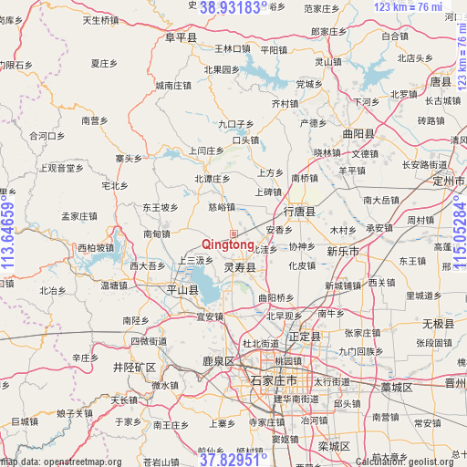
Qingtong GPS coordinates[2]
38° 22' 57.972" North, 114° 20' 58.956" East
| Map corner | latitude | longitude |
|---|---|---|
| Upper-left | 38.93183°, | 113.64659° |
| Center: | 38.38277°, | 114.34971° |
| Lower-right: | 37.82951°, | 115.05284° |
| Map W x H: | 122.6×122.6 km | = 76.2×76.2mi |
| max Lat: | 53.31946° ⇑18.4% North |
| Qingtong: | 38.38277° |
| min Lat: | ⇓81.6% South 18.22056° |
| min Long | Qingtong | max Long |
| 75.07348° | 114.34971° | 134.28917° |
| W 50.6%⇐ | ⇒49.4% E |
Elevation
Elevation of Qingtong is 133 m = 436 ft, and this is 351.8 m = 1154 ft below average elevation for this country.
| Max E: |
5622 m = 18445 ft | 54.8% |
| Avg. | 484.8 m = 1591 ft | |
| Qingtong | 133 m = 436 ft | |
Min E: |
-3 m = -10 ft | 45.2% |
See also: China elevation on elevation.city.
Geographical zone
Qingtong is located in North temperate zone (between Tropic of Cancer and the Arctic Circle). Distance of this Northern Tropic circle is 1661.8 km =1032.6 mi to South.| Distance of | km | miles | from Qingtong |
|---|---|---|---|
| North Pole | 5739.3 | 3566.2 | to North |
| Arctic Circle | 3133.4 | 1947 | to North |
| Tropic Cancer | 1661.8 | 1032.6 | to South |
| Equator | 4267.8 | 2651.9 | to South |


Nearby cities:
15 places around Qingtong: (largest is in red/bold)
• Beitanzhuang
15.5 km =9.6 mi,  339°
339°
• Beiwa
8.9 km =5.5 mi,  114°
114°
• Chengzhai
16.5 km =10.3 mi,  2°
2°
• Ciyu
8 km =5 mi, 336°
• Diying
9.8 km =6.1 mi,  53°
53°
• Goutai
6.4 km =4 mi,  204°
204°
• Huangbizhuang
15 km =9.3 mi,  192°
192°
• Nanyanchuan
14.6 km =9.1 mi,  314°
314°
• Nanzhai
3.9 km =2.4 mi, 110°
• Niucheng
12.9 km =8 mi, 198°
• Sanshengyuan
13 km =8.1 mi,  147°
147°
• Shangbei
14.6 km =9.1 mi,  39°
39°
• Shangsanji
12.5 km =7.8 mi,  237°
237°
• Shitong
14.2 km =8.8 mi,  68°
68°
• Tashang
12.9 km =8 mi,  275°
275°
Sources, notices
• [Note1] Compared only with cities in China existing in our database
• [Src1] Map data: © OpenStreetMap contributors (CC-BY-SA)
• [Src2] Other city data from geonames.org with taken over terms of usage.
• [Src3] Geographical zone / Annual Mean Temperature by Robert A. Rohde @ Wikipedia
