Luodong geodata
Luodong (Guangdong) is a seat of a fourth-order administrative division; located in China in Asia/Shanghai (GMT+8) time zone. In our database, there are 1268 cities with bigger population. Compared to other cities in China, 92.7% of cities are located further ↑North; 64.4% of cities are located further →East and 57.4% of cities have higher elevation than Luodong. Note1


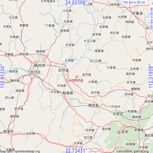
Luodong GPS coordinates[2]
23° 22' 52.536" North, 111° 36' 59.256" East
| Map corner | latitude | longitude |
|---|---|---|
| Upper-left | 24.02506°, | 110.91334° |
| Center: | 23.38126°, | 111.61646° |
| Lower-right: | 22.73431°, | 112.31959° |
| Map W x H: | 143.5×143.5 km | = 89.2×89.2mi |
| max Lat: | 53.31946° ⇑92.7% North |
| Luodong: | 23.38126° |
| min Lat: | ⇓7.3% South 18.22056° |
| min Long | Luodong | max Long |
| 75.07348° | 111.61646° | 134.28917° |
| W 35.6%⇐ | ⇒64.4% E |
Elevation
Elevation of Luodong is 115 m = 377 ft, and this is 369.8 m = 1213 ft below average elevation for this country.
| Max E: |
5622 m = 18445 ft | 57.4% |
| Avg. | 484.8 m = 1591 ft | |
| Luodong | 115 m = 377 ft | |
Min E: |
-3 m = -10 ft | 42.6% |
See also: China elevation on elevation.city.
Geographical zone
Luodong is located in North Torrid zone (between Equator and Tropic of Cancer). Distance of this Northern Tropic circle is 6.2 km =3.9 mi to North.| Distance of | km | miles | from Luodong |
|---|---|---|---|
| North Pole | 7407.3 | 4602.7 | to North |
| Arctic Circle | 4801.4 | 2983.5 | to North |
| Tropic Cancer | 6.2 | 3.9 | to North |
| Equator | 2599.8 | 1615.4 | to South |


Nearby cities:
15 places around Luodong: (largest is in red/bold)
• Baigou
14.1 km =8.8 mi,  7°
7°
• Changgang
12.2 km =7.6 mi,  198°
198°
• Dazhou
17 km =10.6 mi,  332°
332°
• Ducheng
17.9 km =11.1 mi,  210°
210°
• Guanxu
22.8 km =14.2 mi,  127°
127°
• He’erkou
22.3 km =13.9 mi,  50°
50°
• Huilong
22.8 km =14.2 mi,  160°
160°
• Jiangchuan
15 km =9.3 mi,  279°
279°
• Jiangkou
13.7 km =8.5 mi,  297°
297°
• Maxu
27.5 km =17.1 mi,  124°
124°
• Pingfeng
17.3 km =10.7 mi,  239°
239°
• Pingtai
25.1 km =15.6 mi,  234°
234°
• Xinghua
10.4 km =6.5 mi,  78°
78°
• Xinxu
27.9 km =17.3 mi,  147°
147°
• Yulao
17.8 km =11.1 mi,  43°
43°
Sources, notices
• [Note1] Compared only with cities in China existing in our database
• [Src1] Map data: © OpenStreetMap contributors (CC-BY-SA)
• [Src2] Other city data from geonames.org with taken over terms of usage.
• [Src3] Geographical zone / Annual Mean Temperature by Robert A. Rohde @ Wikipedia
