Dazhou geodata
Dazhou (Guangdong) is a seat of a fourth-order administrative division; located in China in Asia/Shanghai (GMT+8) time zone. In our database, there are 1268 cities with bigger population. Compared to other cities in China, 92.1% of cities are located further ↑North; 64.8% of cities are located further →East and 73.7% of cities have higher elevation than Dazhou. Note1


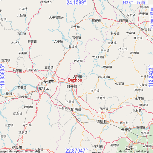
Dazhou GPS coordinates[2]
23° 31' 0.336" North, 111° 32' 21.012" East
| Map corner | latitude | longitude |
|---|---|---|
| Upper-left | 24.1599°, | 110.83605° |
| Center: | 23.51676°, | 111.53917° |
| Lower-right: | 22.87047°, | 112.2423° |
| Map W x H: | 143.4×143.4 km | = 89.1×89.1mi |
| max Lat: | 53.31946° ⇑92.1% North |
| Dazhou: | 23.51676° |
| min Lat: | ⇓7.9% South 18.22056° |
| min Long | Dazhou | max Long |
| 75.07348° | 111.53917° | 134.28917° |
| W 35.2%⇐ | ⇒64.8% E |
Elevation
Elevation of Dazhou is 40 m = 131 ft, and this is 444.8 m = 1459 ft below average elevation for this country.
| Max E: |
5622 m = 18445 ft | 73.7% |
| Avg. | 484.8 m = 1591 ft | |
| Dazhou | 40 m = 131 ft | |
Min E: |
-3 m = -10 ft | 26.3% |
See also: China elevation on elevation.city.
Geographical zone
Dazhou is located in North temperate zone (between Tropic of Cancer and the Arctic Circle). Distance of this Northern Tropic circle is 8.9 km =5.5 mi to South.| Distance of | km | miles | from Dazhou |
|---|---|---|---|
| North Pole | 7392.2 | 4593.3 | to North |
| Arctic Circle | 4786.4 | 2974.1 | to North |
| Tropic Cancer | 8.9 | 5.5 | to South |
| Equator | 2614.8 | 1624.8 | to South |


Nearby cities:
15 places around Dazhou: (largest is in red/bold)
• Baigou
9.8 km =6.1 mi,  96°
96°
• Changgang
26.9 km =16.7 mi,  171°
171°
• Dayukou
27.4 km =17 mi,  46°
46°
• Ducheng
30.6 km =19 mi,  182°
182°
• Duping
20.3 km =12.6 mi, 48°
• He’erkou
25.1 km =15.6 mi,  91°
91°
• Jiangchuan
14.3 km =8.9 mi,  208°
208°
• Jiangkou
9.6 km =6 mi, 206°
• Liandu
29.8 km =18.5 mi,  74°
74°
• Luodong
17 km =10.6 mi,  152°
152°
• Pingfeng
24.8 km =15.4 mi,  196°
196°
• Pingtai
32.2 km =20 mi, 203°
• Wuzhou
23 km =14.3 mi,  260°
260°
• Xinghua
22.3 km =13.9 mi,  125°
125°
• Yulao
20.3 km =12.6 mi, 96°
Sources, notices
• [Note1] Compared only with cities in China existing in our database
• [Src1] Map data: © OpenStreetMap contributors (CC-BY-SA)
• [Src2] Other city data from geonames.org with taken over terms of usage.
• [Src3] Geographical zone / Annual Mean Temperature by Robert A. Rohde @ Wikipedia
