Pingtai geodata
Pingtai (Guangdong) is a seat of a fourth-order administrative division; located in China in Asia/Shanghai (GMT+8) time zone. In our database, there are 1268 cities with bigger population. Compared to other cities in China, 93.2% of cities are located further ↑North; 65.4% of cities are located further →East and 71.9% of cities have higher elevation than Pingtai. Note1


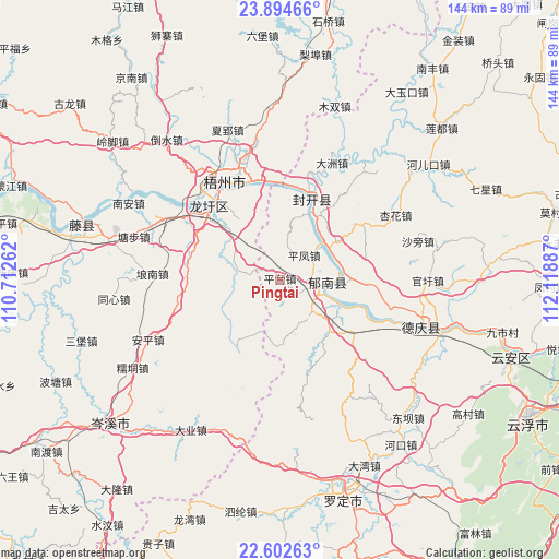
Pingtai GPS coordinates[2]
23° 15' 0.756" North, 111° 24' 56.664" East
| Map corner | latitude | longitude |
|---|---|---|
| Upper-left | 23.89466°, | 110.71262° |
| Center: | 23.25021°, | 111.41574° |
| Lower-right: | 22.60263°, | 112.11887° |
| Map W x H: | 143.7×143.7 km | = 89.3×89.3mi |
| max Lat: | 53.31946° ⇑93.2% North |
| Pingtai: | 23.25021° |
| min Lat: | ⇓6.8% South 18.22056° |
| min Long | Pingtai | max Long |
| 75.07348° | 111.41574° | 134.28917° |
| W 34.6%⇐ | ⇒65.4% E |
Elevation
Elevation of Pingtai is 45 m = 148 ft, and this is 439.8 m = 1443 ft below average elevation for this country.
| Max E: |
5622 m = 18445 ft | 71.9% |
| Avg. | 484.8 m = 1591 ft | |
| Pingtai | 45 m = 148 ft | |
Min E: |
-3 m = -10 ft | 28.1% |
See also: China elevation on elevation.city.
Geographical zone
Pingtai is located in North Torrid zone (between Equator and Tropic of Cancer). Distance of this Northern Tropic circle is 20.7 km =12.9 mi to North.| Distance of | km | miles | from Pingtai |
|---|---|---|---|
| North Pole | 7421.9 | 4611.8 | to North |
| Arctic Circle | 4816 | 2992.5 | to North |
| Tropic Cancer | 20.7 | 12.9 | to North |
| Equator | 2585.2 | 1606.4 | to South |


Nearby cities:
15 places around Pingtai: (largest is in red/bold)
• Baozhu
25 km =15.5 mi,  127°
127°
• Changgang
16.9 km =10.5 mi,  79°
79°
• Dazhou
32.2 km =20 mi,  23°
23°
• Ducheng
11.5 km =7.1 mi,  94°
94°
• Guixu
11.8 km =7.3 mi,  157°
157°
• Huilong
28.9 km =18 mi,  104°
104°
• Jiancheng
17.8 km =11.1 mi,  135°
135°
• Jiangchuan
18.1 km =11.2 mi, 18°
• Jiangkou
22.6 km =14 mi, 21°
• Longxu
26.3 km =16.3 mi,  314°
314°
• Luodong
25.1 km =15.6 mi,  54°
54°
• Pingfeng
8.1 km =5 mi,  42°
42°
• Tongmen
28.3 km =17.6 mi,  168°
168°
• Wuzhou
27.8 km =17.3 mi,  338°
338°
• Xinghua
34.9 km =21.7 mi,  61°
61°
Sources, notices
• [Note1] Compared only with cities in China existing in our database
• [Src1] Map data: © OpenStreetMap contributors (CC-BY-SA)
• [Src2] Other city data from geonames.org with taken over terms of usage.
• [Src3] Geographical zone / Annual Mean Temperature by Robert A. Rohde @ Wikipedia
