Hongxing geodata
Hongxing (Fujian) is a seat of a fourth-order administrative division; located in China in Asia/Shanghai (GMT+8) time zone. In our database, there are 1268 cities with bigger population. Compared to other cities in China, 82.4% of cities are located further ↑North; 75.2% of cities are located further ←West and 78.3% of cities have lower elevation than Hongxing. Note1


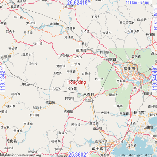
Hongxing GPS coordinates[2]
25° 59' 38.004" North, 118° 50' 14.388" East
| Map corner | latitude | longitude |
|---|---|---|
| Upper-left | 26.62418°, | 118.13421° |
| Center: | 25.99389°, | 118.83733° |
| Lower-right: | 25.3602°, | 119.54046° |
| Map W x H: | 140.5×140.5 km | = 87.3×87.3mi |
| max Lat: | 53.31946° ⇑82.4% North |
| Hongxing: | 25.99389° |
| min Lat: | ⇓17.6% South 18.22056° |
| min Long | Hongxing | max Long |
| 75.07348° | 118.83733° | 134.28917° |
| W 75.2%⇐ | ⇒24.8% E |
Elevation
Elevation of Hongxing is 628 m = 2060 ft, and this is 143.2 m = 470 ft above average elevation for this country.
| Max E: |
5622 m = 18445 ft | 21.7% |
| Hongxing | 628 m 2060 ft | |
| Avg. | 484.8 m = 1591 ft | |
Min E: |
-3 m = -10 ft | 78.3% |
See also: China elevation on elevation.city.
Geographical zone
Hongxing is located in North temperate zone (between Tropic of Cancer and the Arctic Circle). Distance of this Northern Tropic circle is 284.3 km =176.7 mi to South.| Distance of | km | miles | from Hongxing |
|---|---|---|---|
| North Pole | 7116.8 | 4422.2 | to North |
| Arctic Circle | 4510.9 | 2802.9 | to North |
| Tropic Cancer | 284.3 | 176.7 | to South |
| Equator | 2890.2 | 1795.9 | to South |


Nearby cities:
15 places around Hongxing: (largest is in red/bold)
• Baiyun
8.4 km =5.2 mi,  55°
55°
• Baizhong
18.7 km =11.6 mi,  327°
327°
• Bandong
14.9 km =9.3 mi, 332°
• Chengfeng
17 km =10.6 mi,  145°
145°
• Danyun
18.4 km =11.4 mi,  89°
89°
• Fuquan
17.6 km =10.9 mi,  165°
165°
• Pangu
4 km =2.5 mi,  243°
243°
• Qingliang
13.2 km =8.2 mi,  140°
140°
• Sanxi
13.6 km =8.5 mi,  349°
349°
• Shanglian
19.6 km =12.2 mi,  285°
285°
• Shenghuang
11.4 km =7.1 mi,  266°
266°
• Tazhuang
9.5 km =5.9 mi,  314°
314°
• Xiaba
16.6 km =10.3 mi, 243°
• Zhangcheng
19.2 km =11.9 mi, 148°
• Zhangyang
10.4 km =6.5 mi,  214°
214°
Sources, notices
• [Note1] Compared only with cities in China existing in our database
• [Src1] Map data: © OpenStreetMap contributors (CC-BY-SA)
• [Src2] Other city data from geonames.org with taken over terms of usage.
• [Src3] Geographical zone / Annual Mean Temperature by Robert A. Rohde @ Wikipedia
