Qingliang geodata
Qingliang (Fujian) is a seat of a fourth-order administrative division; located in China in Asia/Shanghai (GMT+8) time zone. In our database, there are 1268 cities with bigger population. Compared to other cities in China, 82.8% of cities are located further ↑North; 75.6% of cities are located further ←West and 66.6% of cities have higher elevation than Qingliang. Note1


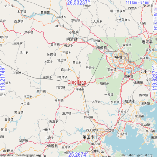
Qingliang GPS coordinates[2]
25° 54' 5.688" North, 118° 55' 14.088" East
| Map corner | latitude | longitude |
|---|---|---|
| Upper-left | 26.53237°, | 118.21746° |
| Center: | 25.90158°, | 118.92058° |
| Lower-right: | 25.2674°, | 119.62371° |
| Map W x H: | 140.7×140.7 km | = 87.4×87.4mi |
| max Lat: | 53.31946° ⇑82.8% North |
| Qingliang: | 25.90158° |
| min Lat: | ⇓17.2% South 18.22056° |
| min Long | Qingliang | max Long |
| 75.07348° | 118.92058° | 134.28917° |
| W 75.6%⇐ | ⇒24.4% E |
Elevation
Elevation of Qingliang is 66 m = 217 ft, and this is 418.8 m = 1374 ft below average elevation for this country.
| Max E: |
5622 m = 18445 ft | 66.6% |
| Avg. | 484.8 m = 1591 ft | |
| Qingliang | 66 m = 217 ft | |
Min E: |
-3 m = -10 ft | 33.4% |
See also: China elevation on elevation.city.
Geographical zone
Qingliang is located in North temperate zone (between Tropic of Cancer and the Arctic Circle). Distance of this Northern Tropic circle is 274.1 km =170.3 mi to South.| Distance of | km | miles | from Qingliang |
|---|---|---|---|
| North Pole | 7127.1 | 4428.6 | to North |
| Arctic Circle | 4521.2 | 2809.3 | to North |
| Tropic Cancer | 274.1 | 170.3 | to South |
| Equator | 2880 | 1789.5 | to South |


Nearby cities:
15 places around Qingliang: (largest is in red/bold)
• Baiyun
15.1 km =9.4 mi,  354°
354°
• Chengfeng
3.9 km =2.4 mi,  160°
160°
• Chixi
14.9 km =9.3 mi,  205°
205°
• Danyun
14.4 km =8.9 mi,  44°
44°
• Fuquan
7.7 km =4.8 mi, 209°
• Geling
15.5 km =9.6 mi,  97°
97°
• Hongxing
13.2 km =8.2 mi,  320°
320°
• Linglu
9.1 km =5.7 mi,  173°
173°
• Pangu
14.6 km =9.1 mi,  305°
305°
• Shenghuang
21.9 km =13.6 mi,  295°
295°
• Tangqian
23.2 km =14.4 mi, 99°
• Tazhuang
22.6 km =14 mi, 318°
• Tong’an
18.2 km =11.3 mi,  245°
245°
• Zhangcheng
6.3 km =3.9 mi, 164°
• Zhangyang
14.2 km =8.8 mi,  276°
276°
Sources, notices
• [Note1] Compared only with cities in China existing in our database
• [Src1] Map data: © OpenStreetMap contributors (CC-BY-SA)
• [Src2] Other city data from geonames.org with taken over terms of usage.
• [Src3] Geographical zone / Annual Mean Temperature by Robert A. Rohde @ Wikipedia
