Pangu geodata
Pangu (Fujian) is a seat of a fourth-order administrative division; located in China in Asia/Shanghai (GMT+8) time zone. In our database, there are 1268 cities with bigger population. Compared to other cities in China, 82.4% of cities are located further ↑North; 75% of cities are located further ←West and 81.9% of cities have lower elevation than Pangu. Note1


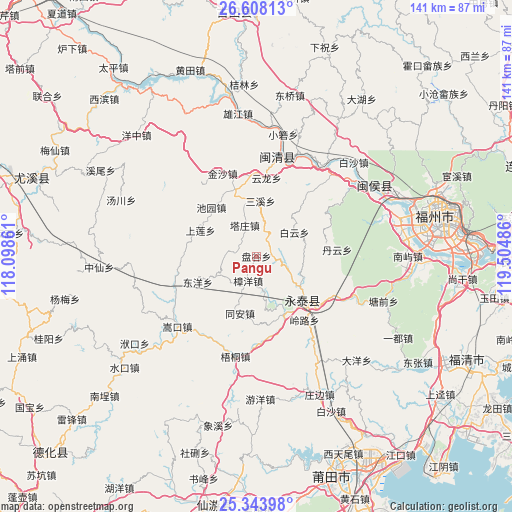
Pangu GPS coordinates[2]
25° 58' 39.9" North, 118° 48' 6.228" East
| Map corner | latitude | longitude |
|---|---|---|
| Upper-left | 26.60813°, | 118.09861° |
| Center: | 25.97775°, | 118.80173° |
| Lower-right: | 25.34398°, | 119.50486° |
| Map W x H: | 140.6×140.6 km | = 87.4×87.4mi |
| max Lat: | 53.31946° ⇑82.4% North |
| Pangu: | 25.97775° |
| min Lat: | ⇓17.6% South 18.22056° |
| min Long | Pangu | max Long |
| 75.07348° | 118.80173° | 134.28917° |
| W 75%⇐ | ⇒25% E |
Elevation
Elevation of Pangu is 785 m = 2575 ft, and this is 300.2 m = 985 ft above average elevation for this country.
| Max E: |
5622 m = 18445 ft | 18.1% |
| Pangu | 785 m 2575 ft | |
| Avg. | 484.8 m = 1591 ft | |
Min E: |
-3 m = -10 ft | 81.9% |
See also: China elevation on elevation.city.
Geographical zone
Pangu is located in North temperate zone (between Tropic of Cancer and the Arctic Circle). Distance of this Northern Tropic circle is 282.5 km =175.5 mi to South.| Distance of | km | miles | from Pangu |
|---|---|---|---|
| North Pole | 7118.6 | 4423.3 | to North |
| Arctic Circle | 4512.7 | 2804.1 | to North |
| Tropic Cancer | 282.5 | 175.5 | to South |
| Equator | 2888.5 | 1794.8 | to South |


Nearby cities:
15 places around Pangu: (largest is in red/bold)
• Baiyun
12.3 km =7.6 mi,  57°
57°
• Bandong
15.3 km =9.5 mi,  347°
347°
• Chengfeng
17.9 km =11.1 mi,  132°
132°
• Chiyuan
18.2 km =11.3 mi,  317°
317°
• Dongyang
17.6 km =10.9 mi,  246°
246°
• Fuquan
17.2 km =10.7 mi,  151°
151°
• Hongxing
4 km =2.5 mi, 63°
• Qingliang
14.6 km =9.1 mi, 125°
• Sanxi
15.2 km =9.4 mi,  4°
4°
• Shanglian
16.9 km =10.5 mi,  294°
294°
• Shenghuang
7.9 km =4.9 mi,  277°
277°
• Tazhuang
9 km =5.6 mi,  339°
339°
• Tong’an
16.8 km =10.4 mi,  195°
195°
• Xiaba
12.6 km =7.8 mi,  243°
243°
• Zhangyang
7.1 km =4.4 mi, 198°
Sources, notices
• [Note1] Compared only with cities in China existing in our database
• [Src1] Map data: © OpenStreetMap contributors (CC-BY-SA)
• [Src2] Other city data from geonames.org with taken over terms of usage.
• [Src3] Geographical zone / Annual Mean Temperature by Robert A. Rohde @ Wikipedia
