Jingfeng geodata
Jingfeng (Fujian) is a populated place; located in China in Asia/Shanghai (GMT+8) time zone. With population of 2,500 people, there are 985 cities with bigger population in this country. Compared to other cities in China, 86.5% of cities are located further ↑North; 75.9% of cities are located further ←West and 88.7% of cities have higher elevation than Jingfeng. Note1


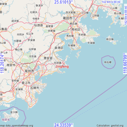
Jingfeng GPS coordinates[2]
24° 58' 27.876" North, 118° 57' 53.496" East
| Map corner | latitude | longitude |
|---|---|---|
| Upper-left | 25.61013°, | 118.26174° |
| Center: | 24.97441°, | 118.96486° |
| Lower-right: | 24.33539°, | 119.66799° |
| Map W x H: | 141.7×141.7 km | = 88×88mi |
| max Lat: | 53.31946° ⇑86.5% North |
| Jingfeng: | 24.97441° |
| min Lat: | ⇓13.5% South 18.22056° |
| min Long | Jingfeng | max Long |
| 75.07348° | 118.96486° | 134.28917° |
| W 75.9%⇐ | ⇒24.1% E |
Elevation
Elevation of Jingfeng is 11 m = 36 ft, and this is 473.8 m = 1554 ft below average elevation for this country.
| Max E: |
5622 m = 18445 ft | 88.7% |
| Avg. | 484.8 m = 1591 ft | |
| Jingfeng | 11 m = 36 ft | |
Min E: |
-3 m = -10 ft | 11.3% |
See also: China elevation on elevation.city.
Geographical zone
Jingfeng is located in North temperate zone (between Tropic of Cancer and the Arctic Circle). Distance of this Northern Tropic circle is 171 km =106.3 mi to South.| Distance of | km | miles | from Jingfeng |
|---|---|---|---|
| North Pole | 7230.2 | 4492.6 | to North |
| Arctic Circle | 4624.3 | 2873.4 | to North |
| Tropic Cancer | 171 | 106.3 | to South |
| Equator | 2776.9 | 1725.5 | to South |


Nearby cities:
15 places around Jingfeng: (largest is in red/bold)
• Baiqi
27.8 km =17.3 mi,  248°
248°
• Dazuo
9.8 km =6.1 mi,  180°
180°
• Donghai
33.8 km =21 mi,  351°
351°
• Dongling
6.8 km =4.2 mi,  277°
277°
• Dongyuan
22.3 km =13.9 mi, 253°
• Fengting
32.2 km =20 mi,  338°
338°
• Jieshan
29.8 km =18.5 mi, 337°
• Lingchuan
35.8 km =22.2 mi,  359°
359°
• Luocheng
18.3 km =11.4 mi,  290°
290°
• Luoyang
28.5 km =17.7 mi,  266°
266°
• Shanxia
9.3 km =5.8 mi,  244°
244°
• Tuzhai
13.4 km =8.3 mi, 274°
• Xiuyu
32 km =19.9 mi,  12°
12°
• Yuetang
32.1 km =19.9 mi,  23°
23°
• Zhongmen
27 km =16.8 mi,  25°
25°
Sources, notices
• [Note1] Compared only with cities in China existing in our database
• [Src1] Map data: © OpenStreetMap contributors (CC-BY-SA)
• [Src2] Other city data from geonames.org with taken over terms of usage.
• [Src3] Geographical zone / Annual Mean Temperature by Robert A. Rohde @ Wikipedia
