Luocheng geodata
Luocheng (Fujian) is a seat of a third-order administrative division; located in China in Asia/Shanghai (GMT+8) time zone. In our database, there are 1268 cities with bigger population. Compared to other cities in China, 86.2% of cities are located further ↑North; 75% of cities are located further ←West and 76.2% of cities have higher elevation than Luocheng. Note1


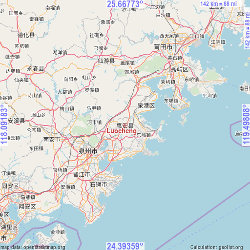
Luocheng GPS coordinates[2]
25° 1' 56.316" North, 118° 47' 41.82" East
| Map corner | latitude | longitude |
|---|---|---|
| Upper-left | 25.66773°, | 118.09183° |
| Center: | 25.03231°, | 118.79495° |
| Lower-right: | 24.39359°, | 119.49808° |
| Map W x H: | 141.7×141.7 km | = 88×88mi |
| max Lat: | 53.31946° ⇑86.2% North |
| Luocheng: | 25.03231° |
| min Lat: | ⇓13.8% South 18.22056° |
| min Long | Luocheng | max Long |
| 75.07348° | 118.79495° | 134.28917° |
| W 75%⇐ | ⇒25% E |
Elevation
Elevation of Luocheng is 34 m = 112 ft, and this is 450.8 m = 1479 ft below average elevation for this country.
| Max E: |
5622 m = 18445 ft | 76.2% |
| Avg. | 484.8 m = 1591 ft | |
| Luocheng | 34 m = 112 ft | |
Min E: |
-3 m = -10 ft | 23.8% |
See also: China elevation on elevation.city.
Geographical zone
Luocheng is located in North temperate zone (between Tropic of Cancer and the Arctic Circle). Distance of this Northern Tropic circle is 177.4 km =110.2 mi to South.| Distance of | km | miles | from Luocheng |
|---|---|---|---|
| North Pole | 7223.7 | 4488.6 | to North |
| Arctic Circle | 4617.8 | 2869.4 | to North |
| Tropic Cancer | 177.4 | 110.2 | to South |
| Equator | 2783.3 | 1729.5 | to South |


Nearby cities:
15 places around Luocheng: (largest is in red/bold)
• Baiqi
18.8 km =11.7 mi,  207°
207°
• Chidian
29.4 km =18.3 mi,  229°
229°
• Dazuo
23.6 km =14.7 mi,  133°
133°
• Dongling
11.7 km =7.3 mi,  117°
117°
• Dongyuan
13.5 km =8.4 mi,  198°
198°
• Fashi
24.4 km =15.2 mi, 226°
• Fengting
24.3 km =15.1 mi,  13°
13°
• Fengzhou
27.6 km =17.1 mi,  252°
252°
• Honglai
28.5 km =17.7 mi,  280°
280°
• Jieshan
22 km =13.7 mi,  15°
15°
• Jingfeng
18.3 km =11.4 mi,  110°
110°
• Luoyang
13.9 km =8.6 mi, 234°
• Quanzhou
24.9 km =15.5 mi,  238°
238°
• Shanxia
13.7 km =8.5 mi,  140°
140°
• Tuzhai
6.6 km =4.1 mi,  145°
145°
Sources, notices
• [Note1] Compared only with cities in China existing in our database
• [Src1] Map data: © OpenStreetMap contributors (CC-BY-SA)
• [Src2] Other city data from geonames.org with taken over terms of usage.
• [Src3] Geographical zone / Annual Mean Temperature by Robert A. Rohde @ Wikipedia
