Luoyang geodata
Luoyang (Fujian) is a populated place; located in China in Asia/Shanghai (GMT+8) time zone. With population of 66,188 people, there are 649 cities with bigger population in this country. Compared to other cities in China, 86.6% of cities are located further ↑North; 74.3% of cities are located further ←West and 84.3% of cities have higher elevation than Luoyang. Note1


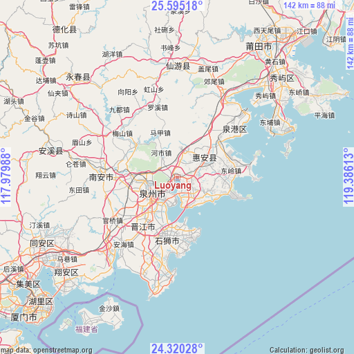
Luoyang GPS coordinates[2]
24° 57' 33.768" North, 118° 40' 58.8" East
| Map corner | latitude | longitude |
|---|---|---|
| Upper-left | 25.59518°, | 117.97988° |
| Center: | 24.95938°, | 118.683° |
| Lower-right: | 24.32028°, | 119.38613° |
| Map W x H: | 141.8×141.8 km | = 88.1×88.1mi |
| max Lat: | 53.31946° ⇑86.6% North |
| Luoyang: | 24.95938° |
| min Lat: | ⇓13.4% South 18.22056° |
| min Long | Luoyang | max Long |
| 75.07348° | 118.683° | 134.28917° |
| W 74.3%⇐ | ⇒25.7% E |
Elevation
Elevation of Luoyang is 17 m = 56 ft, and this is 467.8 m = 1535 ft below average elevation for this country.
| Max E: |
5622 m = 18445 ft | 84.3% |
| Avg. | 484.8 m = 1591 ft | |
| Luoyang | 17 m = 56 ft | |
Min E: |
-3 m = -10 ft | 15.7% |
See also: Luoyang elevation on elevation.city.
Geographical zone
Luoyang is located in North temperate zone (between Tropic of Cancer and the Arctic Circle). Distance of this Northern Tropic circle is 169.3 km =105.2 mi to South.| Distance of | km | miles | from Luoyang |
|---|---|---|---|
| North Pole | 7231.8 | 4493.6 | to North |
| Arctic Circle | 4626 | 2874.5 | to North |
| Tropic Cancer | 169.3 | 105.2 | to South |
| Equator | 2775.2 | 1724.4 | to South |


Nearby cities:
15 places around Luoyang: (largest is in red/bold)
• Baiqi
8.9 km =5.5 mi,  163°
163°
• Chendai
17.4 km =10.8 mi,  208°
208°
• Chidian
15.6 km =9.7 mi,  225°
225°
• Dongling
21.8 km =13.5 mi,  83°
83°
• Dongyuan
8.4 km =5.2 mi,  123°
123°
• Fashi
10.8 km =6.7 mi,  216°
216°
• Fengzhou
15.1 km =9.4 mi,  269°
269°
• Honglai
21.4 km =13.3 mi,  308°
308°
• Jinjiang
19 km =11.8 mi, 215°
• Luocheng
13.9 km =8.6 mi,  54°
54°
• Quanzhou
11 km =6.8 mi,  242°
242°
• Shanxia
20.2 km =12.6 mi,  96°
96°
• Tuzhai
15.2 km =9.4 mi, 80°
• Xiamei
20.7 km =12.9 mi,  263°
263°
• Xibin
18.9 km =11.7 mi,  199°
199°
Sources, notices
• [Note1] Compared only with cities in China existing in our database
• [Src1] Map data: © OpenStreetMap contributors (CC-BY-SA)
• [Src2] Other city data from geonames.org with taken over terms of usage.
• [Src3] Geographical zone / Annual Mean Temperature by Robert A. Rohde @ Wikipedia
