Kuai’an geodata
Kuai’an (Fujian) is a populated place; located in China in Asia/Shanghai (GMT+8) time zone. With population of 3,000 people, there are 949 cities with bigger population in this country. Compared to other cities in China, 82.3% of cities are located further ↑North; 78.3% of cities are located further ←West and 71.9% of cities have higher elevation than Kuai’an. Note1


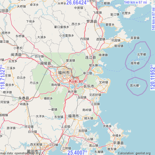
Kuai’an GPS coordinates[2]
26° 2' 3.012" North, 119° 24' 59.004" East
| Map corner | latitude | longitude |
|---|---|---|
| Upper-left | 26.66424°, | 118.71327° |
| Center: | 26.03417°, | 119.41639° |
| Lower-right: | 25.4007°, | 120.11952° |
| Map W x H: | 140.5×140.5 km | = 87.3×87.3mi |
| max Lat: | 53.31946° ⇑82.3% North |
| Kuai’an: | 26.03417° |
| min Lat: | ⇓17.7% South 18.22056° |
| min Long | Kuai’an | max Long |
| 75.07348° | 119.41639° | 134.28917° |
| W 78.3%⇐ | ⇒21.7% E |
Elevation
Elevation of Kuai’an is 45 m = 148 ft, and this is 439.8 m = 1443 ft below average elevation for this country.
| Max E: |
5622 m = 18445 ft | 71.9% |
| Avg. | 484.8 m = 1591 ft | |
| Kuai’an | 45 m = 148 ft | |
Min E: |
-3 m = -10 ft | 28.1% |
See also: China elevation on elevation.city.
Geographical zone
Kuai’an is located in North temperate zone (between Tropic of Cancer and the Arctic Circle). Distance of this Northern Tropic circle is 288.8 km =179.5 mi to South.| Distance of | km | miles | from Kuai’an |
|---|---|---|---|
| North Pole | 7112.3 | 4419.4 | to North |
| Arctic Circle | 4506.4 | 2800.1 | to North |
| Tropic Cancer | 288.8 | 179.5 | to South |
| Equator | 2894.7 | 1798.7 | to South |


Nearby cities:
15 places around Kuai’an: (largest is in red/bold)
• Cangshan
10.8 km =6.7 mi,  272°
272°
• Chengmen
7.1 km =4.4 mi,  230°
230°
• Fuzhou
11.4 km =7.1 mi,  285°
285°
• Gaishan
8.7 km =5.4 mi,  262°
262°
• Guling
6.9 km =4.3 mi,  338°
338°
• Gushan
8.5 km =5.3 mi,  301°
301°
• Houyu
12.2 km =7.6 mi,  76°
76°
• Luozhou
9 km =5.6 mi, 233°
• Minjiang
9 km =5.6 mi,  195°
195°
• Min’an
8.5 km =5.3 mi, 78°
• Shouzhan
12.4 km =7.7 mi,  149°
149°
• Tingjiang
10 km =6.2 mi,  63°
63°
• Xiangqian
10.7 km =6.6 mi, 196°
• Yingqian
8.8 km =5.5 mi, 147°
• Yuefeng
11.7 km =7.3 mi, 303°
Sources, notices
• [Note1] Compared only with cities in China existing in our database
• [Src1] Map data: © OpenStreetMap contributors (CC-BY-SA)
• [Src2] Other city data from geonames.org with taken over terms of usage.
• [Src3] Geographical zone / Annual Mean Temperature by Robert A. Rohde @ Wikipedia
