Chengmen geodata
Chengmen (Fujian) is a seat of a fourth-order administrative division; located in China in Asia/Shanghai (GMT+8) time zone. With population of 4,280 people, there are 886 cities with bigger population in this country. Compared to other cities in China, 82.4% of cities are located further ↑North; 78% of cities are located further ←West and 92.7% of cities have higher elevation than Chengmen. Note1


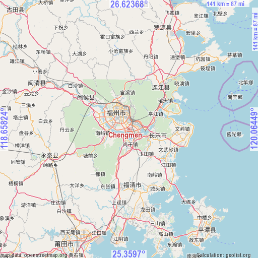
Chengmen GPS coordinates[2]
25° 59' 36.204" North, 119° 21' 40.896" East
| Map corner | latitude | longitude |
|---|---|---|
| Upper-left | 26.62368°, | 118.65824° |
| Center: | 25.99339°, | 119.36136° |
| Lower-right: | 25.3597°, | 120.06449° |
| Map W x H: | 140.5×140.5 km | = 87.3×87.3mi |
| max Lat: | 53.31946° ⇑82.4% North |
| Chengmen: | 25.99339° |
| min Lat: | ⇓17.6% South 18.22056° |
| min Long | Chengmen | max Long |
| 75.07348° | 119.36136° | 134.28917° |
| W 78%⇐ | ⇒22% E |
Elevation
Elevation of Chengmen is 8 m = 26 ft, and this is 476.8 m = 1564 ft below average elevation for this country.
| Max E: |
5622 m = 18445 ft | 92.7% |
| Avg. | 484.8 m = 1591 ft | |
| Chengmen | 8 m = 26 ft | |
Min E: |
-3 m = -10 ft | 7.3% |
See also: China elevation on elevation.city.
Geographical zone
Chengmen is located in North temperate zone (between Tropic of Cancer and the Arctic Circle). Distance of this Northern Tropic circle is 284.3 km =176.7 mi to South.| Distance of | km | miles | from Chengmen |
|---|---|---|---|
| North Pole | 7116.9 | 4422.2 | to North |
| Arctic Circle | 4511 | 2803 | to North |
| Tropic Cancer | 284.3 | 176.7 | to South |
| Equator | 2890.2 | 1795.9 | to South |


Nearby cities:
15 places around Chengmen: (largest is in red/bold)
• Antai
12 km =7.5 mi,  325°
325°
• Cangshan
7.3 km =4.5 mi,  313°
313°
• Fuzhou
9.4 km =5.8 mi,  323°
323°
• Gaishan
4.7 km =2.9 mi, 317°
• Guling
11.4 km =7.1 mi,  15°
15°
• Gulou
12.1 km =7.5 mi, 328°
• Gushan
9.1 km =5.7 mi,  348°
348°
• Kuai’an
7.1 km =4.4 mi,  50°
50°
• Luozhou
1.9 km =1.2 mi,  242°
242°
• Minjiang
5.1 km =3.2 mi,  143°
143°
• Qingkou
11.3 km =7 mi,  167°
167°
• Shanggan
7.4 km =4.6 mi, 173°
• Xiangqian
6.2 km =3.9 mi,  156°
156°
• Yingqian
10.6 km =6.6 mi,  106°
106°
• Yuefeng
11.8 km =7.3 mi,  339°
339°
Sources, notices
• [Note1] Compared only with cities in China existing in our database
• [Src1] Map data: © OpenStreetMap contributors (CC-BY-SA)
• [Src2] Other city data from geonames.org with taken over terms of usage.
• [Src3] Geographical zone / Annual Mean Temperature by Robert A. Rohde @ Wikipedia
