Langkou geodata
Langkou (Fujian) is a seat of a fourth-order administrative division; located in China in Asia/Shanghai (GMT+8) time zone. In our database, there are 1268 cities with bigger population. Compared to other cities in China, 80.8% of cities are located further ↑North; 70% of cities are located further ←West and 58.9% of cities have higher elevation than Langkou. Note1


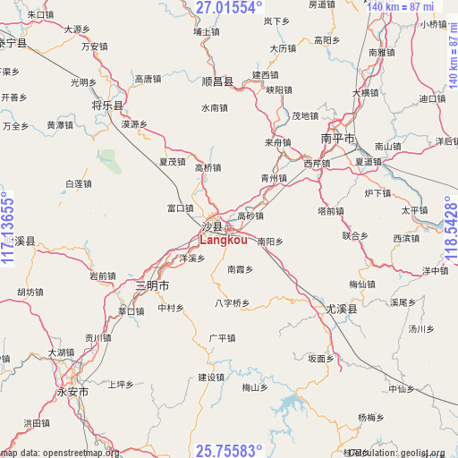
Langkou GPS coordinates[2]
26° 23' 14.64" North, 117° 50' 22.812" East
| Map corner | latitude | longitude |
|---|---|---|
| Upper-left | 27.01554°, | 117.13655° |
| Center: | 26.3874°, | 117.83967° |
| Lower-right: | 25.75583°, | 118.5428° |
| Map W x H: | 140.1×140.1 km | = 87.1×87.1mi |
| max Lat: | 53.31946° ⇑80.8% North |
| Langkou: | 26.3874° |
| min Lat: | ⇓19.2% South 18.22056° |
| min Long | Langkou | max Long |
| 75.07348° | 117.83967° | 134.28917° |
| W 70%⇐ | ⇒30% E |
Elevation
Elevation of Langkou is 105 m = 344 ft, and this is 379.8 m = 1246 ft below average elevation for this country.
| Max E: |
5622 m = 18445 ft | 58.9% |
| Avg. | 484.8 m = 1591 ft | |
| Langkou | 105 m = 344 ft | |
Min E: |
-3 m = -10 ft | 41.1% |
See also: China elevation on elevation.city.
Geographical zone
Langkou is located in North temperate zone (between Tropic of Cancer and the Arctic Circle). Distance of this Northern Tropic circle is 328.1 km =203.9 mi to South.| Distance of | km | miles | from Langkou |
|---|---|---|---|
| North Pole | 7073.1 | 4395 | to North |
| Arctic Circle | 4467.2 | 2775.8 | to North |
| Tropic Cancer | 328.1 | 203.9 | to South |
| Equator | 2934 | 1823.1 | to South |


Nearby cities:
15 places around Langkou: (largest is in red/bold)
• Baziqiao
22.2 km =13.8 mi,  177°
177°
• Chenda
21.1 km =13.1 mi,  247°
247°
• Daluo
16 km =9.9 mi,  198°
198°
• Fukou
16.4 km =10.2 mi,  294°
294°
• Gaoqiao
20.3 km =12.6 mi,  341°
341°
• Gaosha
8 km =5 mi,  55°
55°
• Lishu
26 km =16.2 mi,  331°
331°
• Nankengzai
12.4 km =7.7 mi,  159°
159°
• Nanxia
12.3 km =7.6 mi, 163°
• Nanyang
13.1 km =8.1 mi,  104°
104°
• Qingzhou
21.1 km =13.1 mi,  40°
40°
• Qiujiang
6.5 km =4 mi,  275°
275°
• Xubi
23.9 km =14.9 mi,  239°
239°
• Yangxi
14.1 km =8.8 mi,  233°
233°
• Zhenghu
18.4 km =11.4 mi, 99°
Sources, notices
• [Note1] Compared only with cities in China existing in our database
• [Src1] Map data: © OpenStreetMap contributors (CC-BY-SA)
• [Src2] Other city data from geonames.org with taken over terms of usage.
• [Src3] Geographical zone / Annual Mean Temperature by Robert A. Rohde @ Wikipedia
